You are here: Home > Network List > TA - USArray Transportable Network (new EarthScope stations) Stations List
> Station G63A Kingsbury, ME, USA > Earthquake Result Viewer
G63A Kingsbury, ME, USA - Earthquake Result Viewer
| Earthquake location: |
North Atlantic Ocean |
| Earthquake latitude/longitude: |
13.9/-58.5 |
| Earthquake time(UTC): |
2015/07/16 (197) 15:16:32 GMT |
| Earthquake Depth: |
10 km |
| Earthquake Magnitude: |
6.5 MWW, 6.5 MWC, 6.5 MWB, 6.5 MI |
| Earthquake Catalog/Contributor: |
NEIC PDE/NEIC COMCAT |
|
| Network: |
TA USArray Transportable Network (new EarthScope stations) |
| Station: |
G63A Kingsbury, ME, USA |
| Lat/Lon: |
45.11 N/69.62 W |
| Elevation: |
363 m |
|
| Distance: |
32.5 deg |
| Az: |
345.363 deg |
| Baz: |
159.719 deg |
| Ray Param: |
0.07860609 |
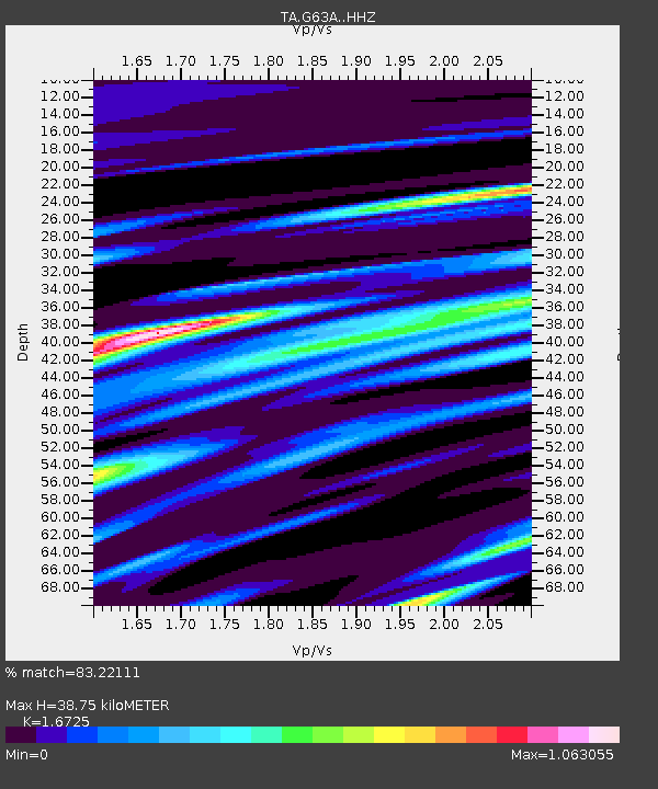
| Estimated Moho Depth: |
38.75 km |
| Estimated Crust Vp/Vs: |
1.67 |
| Assumed Crust Vp: |
6.419 km/s |
| Estimated Crust Vs: |
3.838 km/s |
| Estimated Crust Poisson's Ratio: |
0.22 |
|
| Radial Match: |
83.22111 % |
| Radial Bump: |
350 |
| Transverse Match: |
61.369328 % |
| Transverse Bump: |
400 |
| SOD ConfigId: |
7422571 |
| Insert Time: |
2019-04-19 20:18:47.328 +0000 |
| GWidth: |
2.5 |
| Max Bumps: |
400 |
| Tol: |
0.001 |
|
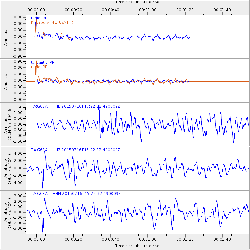
Signal To Noise
| Channel | StoN | STA | LTA |
| TA:G63A: :HHZ:20150716T15:22:32.490009Z | 6.393366 | 2.3067296E-6 | 3.608005E-7 |
| TA:G63A: :HHN:20150716T15:22:32.490009Z | 6.3431377 | 1.4635723E-6 | 2.3073316E-7 |
| TA:G63A: :HHE:20150716T15:22:32.490009Z | 2.501567 | 6.6551524E-7 | 2.6603936E-7 |
| Arrivals |
| Ps | 4.4 SECOND |
| PpPs | 15 SECOND |
| PsPs/PpSs | 19 SECOND |


