You are here: Home > Network List > TA - USArray Transportable Network (new EarthScope stations) Stations List
> Station I60A Shoreham, VT, USA > Earthquake Result Viewer
I60A Shoreham, VT, USA - Earthquake Result Viewer
| Earthquake location: |
North Atlantic Ocean |
| Earthquake latitude/longitude: |
13.9/-58.5 |
| Earthquake time(UTC): |
2015/07/16 (197) 15:16:32 GMT |
| Earthquake Depth: |
10 km |
| Earthquake Magnitude: |
6.5 MWW, 6.5 MWC, 6.5 MWB, 6.5 MI |
| Earthquake Catalog/Contributor: |
NEIC PDE/NEIC COMCAT |
|
| Network: |
TA USArray Transportable Network (new EarthScope stations) |
| Station: |
I60A Shoreham, VT, USA |
| Lat/Lon: |
43.84 N/73.29 W |
| Elevation: |
101 m |
|
| Distance: |
32.4 deg |
| Az: |
339.93 deg |
| Baz: |
152.571 deg |
| Ray Param: |
0.07864789 |
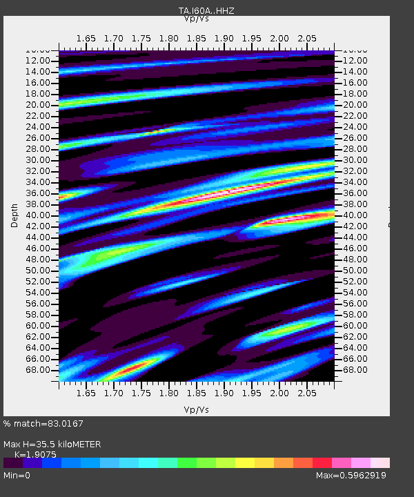
| Estimated Moho Depth: |
35.5 km |
| Estimated Crust Vp/Vs: |
1.91 |
| Assumed Crust Vp: |
6.419 km/s |
| Estimated Crust Vs: |
3.365 km/s |
| Estimated Crust Poisson's Ratio: |
0.31 |
|
| Radial Match: |
83.0167 % |
| Radial Bump: |
400 |
| Transverse Match: |
48.382015 % |
| Transverse Bump: |
400 |
| SOD ConfigId: |
7422571 |
| Insert Time: |
2019-04-19 20:19:08.580 +0000 |
| GWidth: |
2.5 |
| Max Bumps: |
400 |
| Tol: |
0.001 |
|

Signal To Noise
| Channel | StoN | STA | LTA |
| TA:I60A: :HHZ:20150716T15:22:31.599994Z | 2.9069936 | 1.4742141E-6 | 5.071267E-7 |
| TA:I60A: :HHN:20150716T15:22:31.599994Z | 2.3796597 | 8.1298793E-7 | 3.4164043E-7 |
| TA:I60A: :HHE:20150716T15:22:31.599994Z | 1.6571959 | 5.1928487E-7 | 3.133515E-7 |
| Arrivals |
| Ps | 5.4 SECOND |
| PpPs | 15 SECOND |
| PsPs/PpSs | 20 SECOND |


