You are here: Home > Network List > TA - USArray Transportable Network (new EarthScope stations) Stations List
> Station I64A Boothbay, ME, USA > Earthquake Result Viewer
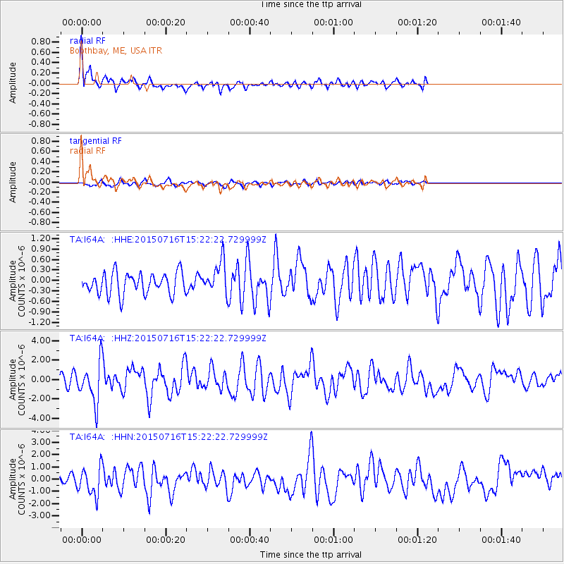
I64A Boothbay, ME, USA - Earthquake Result Viewer
*The percent match for this event was below the threshold and hence no stack was calculated.
| Earthquake location: |
North Atlantic Ocean |
| Earthquake latitude/longitude: |
13.9/-58.5 |
| Earthquake time(UTC): |
2015/07/16 (197) 15:16:32 GMT |
| Earthquake Depth: |
10 km |
| Earthquake Magnitude: |
6.5 MWW, 6.5 MWC, 6.5 MWB, 6.5 MI |
| Earthquake Catalog/Contributor: |
NEIC PDE/NEIC COMCAT |
|
| Network: |
TA USArray Transportable Network (new EarthScope stations) |
| Station: |
I64A Boothbay, ME, USA |
| Lat/Lon: |
43.92 N/69.63 W |
| Elevation: |
17 m |
|
| Distance: |
31.4 deg |
| Az: |
344.548 deg |
| Baz: |
159.017 deg |
| Ray Param: |
$rayparam |
*The percent match for this event was below the threshold and hence was not used in the summary stack. |
|
| Radial Match: |
74.31289 % |
| Radial Bump: |
400 |
| Transverse Match: |
66.30059 % |
| Transverse Bump: |
366 |
| SOD ConfigId: |
7422571 |
| Insert Time: |
2019-04-19 20:19:10.721 +0000 |
| GWidth: |
2.5 |
| Max Bumps: |
400 |
| Tol: |
0.001 |
|
Signal To Noise
| Channel | StoN | STA | LTA |
| TA:I64A: :HHZ:20150716T15:22:22.729999Z | 2.9445555 | 2.1836101E-6 | 7.4157543E-7 |
| TA:I64A: :HHN:20150716T15:22:22.729999Z | 2.469022 | 1.187133E-6 | 4.80811E-7 |
| TA:I64A: :HHE:20150716T15:22:22.729999Z | 1.6267498 | 4.9868004E-7 | 3.0654994E-7 |
| Arrivals |
| Ps | |
| PpPs | |
| PsPs/PpSs | |


