You are here: Home > Network List > TA - USArray Transportable Network (new EarthScope stations) Stations List
> Station J58A Remsen, NY, USA > Earthquake Result Viewer
J58A Remsen, NY, USA - Earthquake Result Viewer
| Earthquake location: |
North Atlantic Ocean |
| Earthquake latitude/longitude: |
13.9/-58.5 |
| Earthquake time(UTC): |
2015/07/16 (197) 15:16:32 GMT |
| Earthquake Depth: |
10 km |
| Earthquake Magnitude: |
6.5 MWW, 6.5 MWC, 6.5 MWB, 6.5 MI |
| Earthquake Catalog/Contributor: |
NEIC PDE/NEIC COMCAT |
|
| Network: |
TA USArray Transportable Network (new EarthScope stations) |
| Station: |
J58A Remsen, NY, USA |
| Lat/Lon: |
43.36 N/75.29 W |
| Elevation: |
436 m |
|
| Distance: |
32.7 deg |
| Az: |
337.146 deg |
| Baz: |
148.854 deg |
| Ray Param: |
0.0785259 |
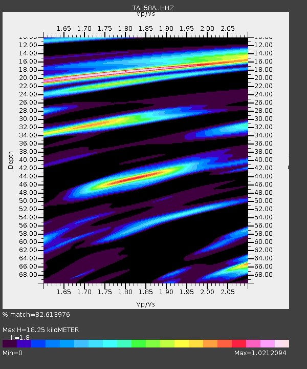
| Estimated Moho Depth: |
18.25 km |
| Estimated Crust Vp/Vs: |
1.80 |
| Assumed Crust Vp: |
6.419 km/s |
| Estimated Crust Vs: |
3.566 km/s |
| Estimated Crust Poisson's Ratio: |
0.28 |
|
| Radial Match: |
82.613976 % |
| Radial Bump: |
303 |
| Transverse Match: |
54.594135 % |
| Transverse Bump: |
400 |
| SOD ConfigId: |
7422571 |
| Insert Time: |
2019-04-19 20:19:13.599 +0000 |
| GWidth: |
2.5 |
| Max Bumps: |
400 |
| Tol: |
0.001 |
|

Signal To Noise
| Channel | StoN | STA | LTA |
| TA:J58A: :HHZ:20150716T15:22:34.090015Z | 2.7664778 | 1.1460285E-6 | 4.1425545E-7 |
| TA:J58A: :HHN:20150716T15:22:34.090015Z | 2.443372 | 7.068199E-7 | 2.892805E-7 |
| TA:J58A: :HHE:20150716T15:22:34.090015Z | 1.4634401 | 4.142039E-7 | 2.830344E-7 |
| Arrivals |
| Ps | 2.5 SECOND |
| PpPs | 7.4 SECOND |
| PsPs/PpSs | 9.8 SECOND |


