You are here: Home > Network List > TA - USArray Transportable Network (new EarthScope stations) Stations List
> Station L58A Harry Jones Memorial, Binghamton, NY, USA > Earthquake Result Viewer
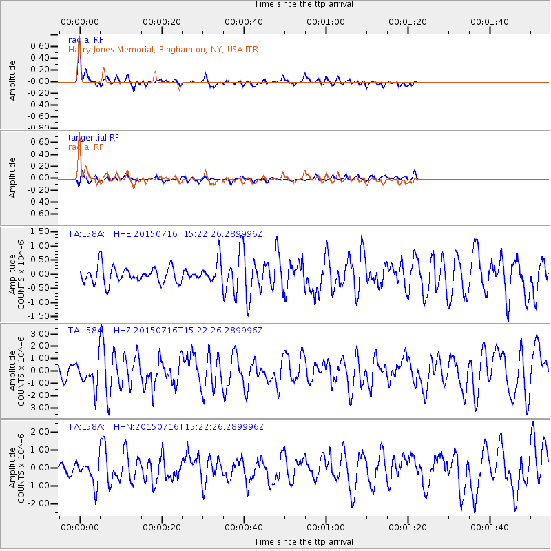
L58A Harry Jones Memorial, Binghamton, NY, USA - Earthquake Result Viewer
*The percent match for this event was below the threshold and hence no stack was calculated.
| Earthquake location: |
North Atlantic Ocean |
| Earthquake latitude/longitude: |
13.9/-58.5 |
| Earthquake time(UTC): |
2015/07/16 (197) 15:16:32 GMT |
| Earthquake Depth: |
10 km |
| Earthquake Magnitude: |
6.5 MWW, 6.5 MWC, 6.5 MWB, 6.5 MI |
| Earthquake Catalog/Contributor: |
NEIC PDE/NEIC COMCAT |
|
| Network: |
TA USArray Transportable Network (new EarthScope stations) |
| Station: |
L58A Harry Jones Memorial, Binghamton, NY, USA |
| Lat/Lon: |
42.04 N/75.85 W |
| Elevation: |
447 m |
|
| Distance: |
31.8 deg |
| Az: |
335.175 deg |
| Baz: |
146.807 deg |
| Ray Param: |
$rayparam |
*The percent match for this event was below the threshold and hence was not used in the summary stack. |
|
| Radial Match: |
64.63473 % |
| Radial Bump: |
383 |
| Transverse Match: |
59.68302 % |
| Transverse Bump: |
400 |
| SOD ConfigId: |
7422571 |
| Insert Time: |
2019-04-19 20:19:30.000 +0000 |
| GWidth: |
2.5 |
| Max Bumps: |
400 |
| Tol: |
0.001 |
|
Signal To Noise
| Channel | StoN | STA | LTA |
| TA:L58A: :HHZ:20150716T15:22:26.289996Z | 2.0374415 | 1.2143839E-6 | 5.960338E-7 |
| TA:L58A: :HHN:20150716T15:22:26.289996Z | 2.1099434 | 7.428183E-7 | 3.5205605E-7 |
| TA:L58A: :HHE:20150716T15:22:26.289996Z | 1.5429798 | 4.4605548E-7 | 2.8908704E-7 |
| Arrivals |
| Ps | |
| PpPs | |
| PsPs/PpSs | |


