You are here: Home > Network List > TA - USArray Transportable Network (new EarthScope stations) Stations List
> Station M26K Nabesna, AK, USA > Earthquake Result Viewer
M26K Nabesna, AK, USA - Earthquake Result Viewer
| Earthquake location: |
North Atlantic Ocean |
| Earthquake latitude/longitude: |
13.9/-58.5 |
| Earthquake time(UTC): |
2015/07/16 (197) 15:16:32 GMT |
| Earthquake Depth: |
10 km |
| Earthquake Magnitude: |
6.5 MWW, 6.5 MWC, 6.5 MWB, 6.5 MI |
| Earthquake Catalog/Contributor: |
NEIC PDE/NEIC COMCAT |
|
| Network: |
TA USArray Transportable Network (new EarthScope stations) |
| Station: |
M26K Nabesna, AK, USA |
| Lat/Lon: |
62.40 N/143.00 W |
| Elevation: |
888 m |
|
| Distance: |
75.3 deg |
| Az: |
331.36 deg |
| Baz: |
88.362 deg |
| Ray Param: |
0.05178577 |
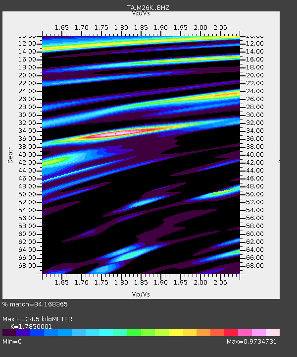
| Estimated Moho Depth: |
34.5 km |
| Estimated Crust Vp/Vs: |
1.79 |
| Assumed Crust Vp: |
6.566 km/s |
| Estimated Crust Vs: |
3.679 km/s |
| Estimated Crust Poisson's Ratio: |
0.27 |
|
| Radial Match: |
84.168365 % |
| Radial Bump: |
400 |
| Transverse Match: |
57.73992 % |
| Transverse Bump: |
400 |
| SOD ConfigId: |
7422571 |
| Insert Time: |
2019-04-19 20:19:36.159 +0000 |
| GWidth: |
2.5 |
| Max Bumps: |
400 |
| Tol: |
0.001 |
|

Signal To Noise
| Channel | StoN | STA | LTA |
| TA:M26K: :BHZ:20150716T15:27:43.450Z | 5.259628 | 3.2095983E-7 | 6.102329E-8 |
| TA:M26K: :BHN:20150716T15:27:43.450Z | 0.85395163 | 6.703949E-8 | 7.850502E-8 |
| TA:M26K: :BHE:20150716T15:27:43.450Z | 1.9611119 | 1.2794037E-7 | 6.523869E-8 |
| Arrivals |
| Ps | 4.3 SECOND |
| PpPs | 14 SECOND |
| PsPs/PpSs | 18 SECOND |


