You are here: Home > Network List > TA - USArray Transportable Network (new EarthScope stations) Stations List
> Station O56A Blue Knob State Park, Imler, PA, USA > Earthquake Result Viewer
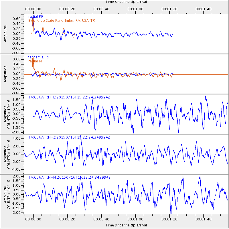
O56A Blue Knob State Park, Imler, PA, USA - Earthquake Result Viewer
| Earthquake location: |
North Atlantic Ocean |
| Earthquake latitude/longitude: |
13.9/-58.5 |
| Earthquake time(UTC): |
2015/07/16 (197) 15:16:32 GMT |
| Earthquake Depth: |
10 km |
| Earthquake Magnitude: |
6.5 MWW, 6.5 MWC, 6.5 MWB, 6.5 MI |
| Earthquake Catalog/Contributor: |
NEIC PDE/NEIC COMCAT |
|
| Network: |
TA USArray Transportable Network (new EarthScope stations) |
| Station: |
O56A Blue Knob State Park, Imler, PA, USA |
| Lat/Lon: |
40.27 N/78.57 W |
| Elevation: |
684 m |
|
| Distance: |
31.6 deg |
| Az: |
330.035 deg |
| Baz: |
140.652 deg |
| Ray Param: |
0.07899742 |
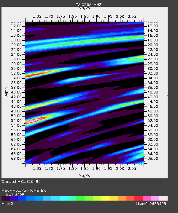
| Estimated Moho Depth: |
51.75 km |
| Estimated Crust Vp/Vs: |
1.63 |
| Assumed Crust Vp: |
6.121 km/s |
| Estimated Crust Vs: |
3.749 km/s |
| Estimated Crust Poisson's Ratio: |
0.20 |
|
| Radial Match: |
81.319496 % |
| Radial Bump: |
400 |
| Transverse Match: |
47.9526 % |
| Transverse Bump: |
400 |
| SOD ConfigId: |
7422571 |
| Insert Time: |
2019-04-19 20:19:46.683 +0000 |
| GWidth: |
2.5 |
| Max Bumps: |
400 |
| Tol: |
0.001 |
|
Signal To Noise
| Channel | StoN | STA | LTA |
| TA:O56A: :HHZ:20150716T15:22:24.349994Z | 1.7235315 | 7.5466517E-7 | 4.3785982E-7 |
| TA:O56A: :HHN:20150716T15:22:24.349994Z | 1.2064545 | 3.3416242E-7 | 2.7697888E-7 |
| TA:O56A: :HHE:20150716T15:22:24.349994Z | 2.28405 | 8.130042E-7 | 3.5594852E-7 |
| Arrivals |
| Ps | 5.8 SECOND |
| PpPs | 21 SECOND |
| PsPs/PpSs | 26 SECOND |


