You are here: Home > Network List > TA - USArray Transportable Network (new EarthScope stations) Stations List
> Station W18A Petrified Forest, AZ, USA > Earthquake Result Viewer
W18A Petrified Forest, AZ, USA - Earthquake Result Viewer
| Earthquake location: |
North Atlantic Ocean |
| Earthquake latitude/longitude: |
13.9/-58.5 |
| Earthquake time(UTC): |
2015/07/16 (197) 15:16:32 GMT |
| Earthquake Depth: |
10 km |
| Earthquake Magnitude: |
6.5 MWW, 6.5 MWC, 6.5 MWB, 6.5 MI |
| Earthquake Catalog/Contributor: |
NEIC PDE/NEIC COMCAT |
|
| Network: |
TA USArray Transportable Network (new EarthScope stations) |
| Station: |
W18A Petrified Forest, AZ, USA |
| Lat/Lon: |
35.12 N/109.74 W |
| Elevation: |
1750 m |
|
| Distance: |
50.6 deg |
| Az: |
304.191 deg |
| Baz: |
101.471 deg |
| Ray Param: |
0.06797917 |
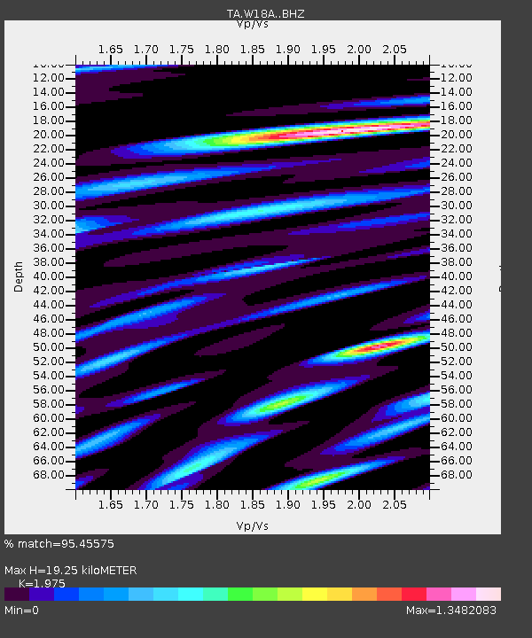
| Estimated Moho Depth: |
19.25 km |
| Estimated Crust Vp/Vs: |
1.98 |
| Assumed Crust Vp: |
6.496 km/s |
| Estimated Crust Vs: |
3.289 km/s |
| Estimated Crust Poisson's Ratio: |
0.33 |
|
| Radial Match: |
95.45575 % |
| Radial Bump: |
348 |
| Transverse Match: |
86.5264 % |
| Transverse Bump: |
400 |
| SOD ConfigId: |
7422571 |
| Insert Time: |
2019-04-19 20:19:57.021 +0000 |
| GWidth: |
2.5 |
| Max Bumps: |
400 |
| Tol: |
0.001 |
|

Signal To Noise
| Channel | StoN | STA | LTA |
| TA:W18A: :BHZ:20150716T15:24:59.300006Z | 16.555807 | 1.6842589E-6 | 1.0173222E-7 |
| TA:W18A: :BHN:20150716T15:24:59.300006Z | 1.3625529 | 2.0090191E-7 | 1.4744522E-7 |
| TA:W18A: :BHE:20150716T15:24:59.300006Z | 7.5081897 | 6.577693E-7 | 8.7606914E-8 |
| Arrivals |
| Ps | 3.0 SECOND |
| PpPs | 8.4 SECOND |
| PsPs/PpSs | 11 SECOND |


