You are here: Home > Network List > WU - The Southern Ontario Seismic Network Stations List
> Station DELO Deloro Mine, Ontario, Canada > Earthquake Result Viewer
DELO Deloro Mine, Ontario, Canada - Earthquake Result Viewer
| Earthquake location: |
North Atlantic Ocean |
| Earthquake latitude/longitude: |
13.9/-58.5 |
| Earthquake time(UTC): |
2015/07/16 (197) 15:16:32 GMT |
| Earthquake Depth: |
10 km |
| Earthquake Magnitude: |
6.5 MWW, 6.5 MWC, 6.5 MWB, 6.5 MI |
| Earthquake Catalog/Contributor: |
NEIC PDE/NEIC COMCAT |
|
| Network: |
WU The Southern Ontario Seismic Network |
| Station: |
DELO Deloro Mine, Ontario, Canada |
| Lat/Lon: |
44.52 N/77.62 W |
| Elevation: |
213 m |
|
| Distance: |
34.6 deg |
| Az: |
335.706 deg |
| Baz: |
146.042 deg |
| Ray Param: |
0.07764958 |
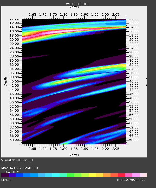
| Estimated Moho Depth: |
15.5 km |
| Estimated Crust Vp/Vs: |
1.82 |
| Assumed Crust Vp: |
6.577 km/s |
| Estimated Crust Vs: |
3.624 km/s |
| Estimated Crust Poisson's Ratio: |
0.28 |
|
| Radial Match: |
81.70151 % |
| Radial Bump: |
292 |
| Transverse Match: |
65.60219 % |
| Transverse Bump: |
280 |
| SOD ConfigId: |
7422571 |
| Insert Time: |
2019-04-19 20:21:00.761 +0000 |
| GWidth: |
2.5 |
| Max Bumps: |
400 |
| Tol: |
0.001 |
|

Signal To Noise
| Channel | StoN | STA | LTA |
| WU:DELO: :HHZ:20150716T15:22:50.400012Z | 3.616434 | 1.227507E-6 | 3.394247E-7 |
| WU:DELO: :HHN:20150716T15:22:50.400012Z | 3.5108213 | 5.9554907E-7 | 1.696324E-7 |
| WU:DELO: :HHE:20150716T15:22:50.400012Z | 2.2312186 | 4.6015145E-7 | 2.0623324E-7 |
| Arrivals |
| Ps | 2.1 SECOND |
| PpPs | 6.1 SECOND |
| PsPs/PpSs | 8.2 SECOND |


