You are here: Home > Network List > WU - The Southern Ontario Seismic Network Stations List
> Station PLIO Pelee Island, Stone Alvar Conservation Area, Ontario, Canad > Earthquake Result Viewer
PLIO Pelee Island, Stone Alvar Conservation Area, Ontario, Canad - Earthquake Result Viewer
| Earthquake location: |
North Atlantic Ocean |
| Earthquake latitude/longitude: |
13.9/-58.5 |
| Earthquake time(UTC): |
2015/07/16 (197) 15:16:32 GMT |
| Earthquake Depth: |
10 km |
| Earthquake Magnitude: |
6.5 MWW, 6.5 MWC, 6.5 MWB, 6.5 MI |
| Earthquake Catalog/Contributor: |
NEIC PDE/NEIC COMCAT |
|
| Network: |
WU The Southern Ontario Seismic Network |
| Station: |
PLIO Pelee Island, Stone Alvar Conservation Area, Ontario, Canad |
| Lat/Lon: |
41.75 N/82.63 W |
| Elevation: |
143 m |
|
| Distance: |
34.8 deg |
| Az: |
327.639 deg |
| Baz: |
135.991 deg |
| Ray Param: |
0.07756736 |
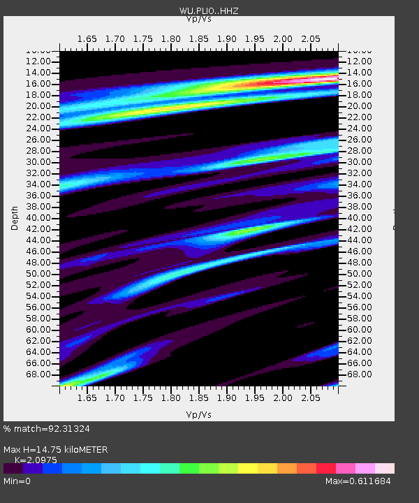
| Estimated Moho Depth: |
14.75 km |
| Estimated Crust Vp/Vs: |
2.10 |
| Assumed Crust Vp: |
6.498 km/s |
| Estimated Crust Vs: |
3.098 km/s |
| Estimated Crust Poisson's Ratio: |
0.35 |
|
| Radial Match: |
92.31324 % |
| Radial Bump: |
400 |
| Transverse Match: |
69.99059 % |
| Transverse Bump: |
400 |
| SOD ConfigId: |
7422571 |
| Insert Time: |
2019-04-19 20:21:07.411 +0000 |
| GWidth: |
2.5 |
| Max Bumps: |
400 |
| Tol: |
0.001 |
|

Signal To Noise
| Channel | StoN | STA | LTA |
| WU:PLIO: :HHZ:20150716T15:22:51.719012Z | 3.488562 | 6.1290416E-7 | 1.7568962E-7 |
| WU:PLIO: :HHN:20150716T15:22:51.719012Z | 3.308851 | 4.1378425E-7 | 1.2505376E-7 |
| WU:PLIO: :HHE:20150716T15:22:51.719012Z | 1.842951 | 3.5263503E-7 | 1.9134258E-7 |
| Arrivals |
| Ps | 2.7 SECOND |
| PpPs | 6.6 SECOND |
| PsPs/PpSs | 9.2 SECOND |


