You are here: Home > Network List > XD14 - Illuminating the architecture of the greater Mount St. Helens magmatic systems f Stations List
> Station MD09 "Mount St Helens, WA" > Earthquake Result Viewer
MD09 "Mount St Helens, WA" - Earthquake Result Viewer
| Earthquake location: |
North Atlantic Ocean |
| Earthquake latitude/longitude: |
13.9/-58.5 |
| Earthquake time(UTC): |
2015/07/16 (197) 15:16:32 GMT |
| Earthquake Depth: |
10 km |
| Earthquake Magnitude: |
6.5 MWW, 6.5 MWC, 6.5 MWB, 6.5 MI |
| Earthquake Catalog/Contributor: |
NEIC PDE/NEIC COMCAT |
|
| Network: |
XD Illuminating the architecture of the greater Mount St. Helens magmatic systems f |
| Station: |
MD09 "Mount St Helens, WA" |
| Lat/Lon: |
46.50 N/121.71 W |
| Elevation: |
959 m |
|
| Distance: |
61.6 deg |
| Az: |
315.543 deg |
| Baz: |
99.997 deg |
| Ray Param: |
0.06074531 |
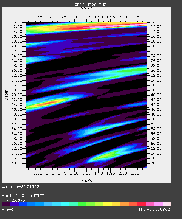
| Estimated Moho Depth: |
11.0 km |
| Estimated Crust Vp/Vs: |
2.07 |
| Assumed Crust Vp: |
6.597 km/s |
| Estimated Crust Vs: |
3.191 km/s |
| Estimated Crust Poisson's Ratio: |
0.35 |
|
| Radial Match: |
86.51522 % |
| Radial Bump: |
400 |
| Transverse Match: |
82.88324 % |
| Transverse Bump: |
400 |
| SOD ConfigId: |
7422571 |
| Insert Time: |
2019-04-19 20:21:26.913 +0000 |
| GWidth: |
2.5 |
| Max Bumps: |
400 |
| Tol: |
0.001 |
|

Signal To Noise
| Channel | StoN | STA | LTA |
| XD:MD09: :BHZ:20150716T15:26:18.43999Z | 5.4484973 | 6.560435E-7 | 1.2040815E-7 |
| XD:MD09: :BHN:20150716T15:26:18.43999Z | 0.68900836 | 6.190066E-8 | 8.984021E-8 |
| XD:MD09: :BHE:20150716T15:26:18.43999Z | 1.8854715 | 1.8386402E-7 | 9.75162E-8 |
| Arrivals |
| Ps | 1.9 SECOND |
| PpPs | 4.9 SECOND |
| PsPs/PpSs | 6.8 SECOND |


