You are here: Home > Network List > XD14 - Illuminating the architecture of the greater Mount St. Helens magmatic systems f Stations List
> Station MH01 "Mount St Helens, WA" > Earthquake Result Viewer
MH01 "Mount St Helens, WA" - Earthquake Result Viewer
| Earthquake location: |
North Atlantic Ocean |
| Earthquake latitude/longitude: |
13.9/-58.5 |
| Earthquake time(UTC): |
2015/07/16 (197) 15:16:32 GMT |
| Earthquake Depth: |
10 km |
| Earthquake Magnitude: |
6.5 MWW, 6.5 MWC, 6.5 MWB, 6.5 MI |
| Earthquake Catalog/Contributor: |
NEIC PDE/NEIC COMCAT |
|
| Network: |
XD Illuminating the architecture of the greater Mount St. Helens magmatic systems f |
| Station: |
MH01 "Mount St Helens, WA" |
| Lat/Lon: |
46.26 N/122.81 W |
| Elevation: |
197 m |
|
| Distance: |
62.4 deg |
| Az: |
315.133 deg |
| Baz: |
99.012 deg |
| Ray Param: |
0.060283843 |
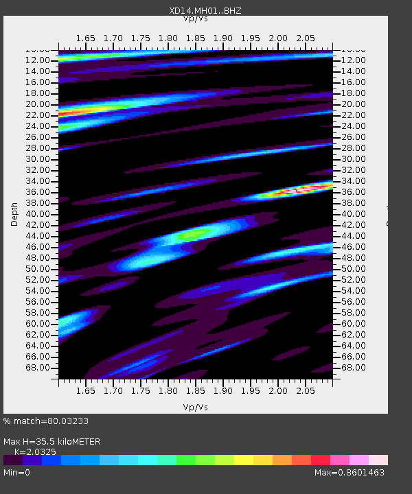
| Estimated Moho Depth: |
35.5 km |
| Estimated Crust Vp/Vs: |
2.03 |
| Assumed Crust Vp: |
6.566 km/s |
| Estimated Crust Vs: |
3.231 km/s |
| Estimated Crust Poisson's Ratio: |
0.34 |
|
| Radial Match: |
80.03233 % |
| Radial Bump: |
400 |
| Transverse Match: |
63.885983 % |
| Transverse Bump: |
400 |
| SOD ConfigId: |
7422571 |
| Insert Time: |
2019-04-19 20:21:38.282 +0000 |
| GWidth: |
2.5 |
| Max Bumps: |
400 |
| Tol: |
0.001 |
|

Signal To Noise
| Channel | StoN | STA | LTA |
| XD:MH01: :BHZ:20150716T15:26:23.205005Z | 5.4466186 | 8.5425194E-7 | 1.5684078E-7 |
| XD:MH01: :BHN:20150716T15:26:23.205005Z | 0.76369953 | 1.677609E-7 | 2.1966872E-7 |
| XD:MH01: :BHE:20150716T15:26:23.205005Z | 1.5155786 | 2.3775507E-7 | 1.5687412E-7 |
| Arrivals |
| Ps | 5.8 SECOND |
| PpPs | 16 SECOND |
| PsPs/PpSs | 22 SECOND |


