You are here: Home > Network List > XD14 - Illuminating the architecture of the greater Mount St. Helens magmatic systems f Stations List
> Station MO06 "Mount St Helens, WA" > Earthquake Result Viewer
MO06 "Mount St Helens, WA" - Earthquake Result Viewer
| Earthquake location: |
North Atlantic Ocean |
| Earthquake latitude/longitude: |
13.9/-58.5 |
| Earthquake time(UTC): |
2015/07/16 (197) 15:16:32 GMT |
| Earthquake Depth: |
10 km |
| Earthquake Magnitude: |
6.5 MWW, 6.5 MWC, 6.5 MWB, 6.5 MI |
| Earthquake Catalog/Contributor: |
NEIC PDE/NEIC COMCAT |
|
| Network: |
XD Illuminating the architecture of the greater Mount St. Helens magmatic systems f |
| Station: |
MO06 "Mount St Helens, WA" |
| Lat/Lon: |
45.93 N/122.21 W |
| Elevation: |
784 m |
|
| Distance: |
61.9 deg |
| Az: |
314.838 deg |
| Baz: |
99.305 deg |
| Ray Param: |
0.060589384 |
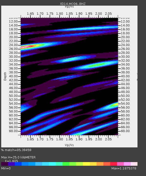
| Estimated Moho Depth: |
25.0 km |
| Estimated Crust Vp/Vs: |
1.61 |
| Assumed Crust Vp: |
6.566 km/s |
| Estimated Crust Vs: |
4.091 km/s |
| Estimated Crust Poisson's Ratio: |
0.18 |
|
| Radial Match: |
85.39459 % |
| Radial Bump: |
400 |
| Transverse Match: |
79.3232 % |
| Transverse Bump: |
400 |
| SOD ConfigId: |
7422571 |
| Insert Time: |
2019-04-19 20:22:07.477 +0000 |
| GWidth: |
2.5 |
| Max Bumps: |
400 |
| Tol: |
0.001 |
|

Signal To Noise
| Channel | StoN | STA | LTA |
| XD:MO06: :BHZ:20150716T15:26:20.090015Z | 6.542735 | 6.13037E-7 | 9.369736E-8 |
| XD:MO06: :BHN:20150716T15:26:20.090015Z | 1.939457 | 1.6156686E-7 | 8.33052E-8 |
| XD:MO06: :BHE:20150716T15:26:20.090015Z | 2.525688 | 2.5482538E-7 | 1.0089346E-7 |
| Arrivals |
| Ps | 2.4 SECOND |
| PpPs | 9.4 SECOND |
| PsPs/PpSs | 12 SECOND |


