You are here: Home > Network List > GS - US Geological Survey Networks Stations List
> Station DEC05 Decatur Surface Seismic Site, Decatur, IL, USA > Earthquake Result Viewer
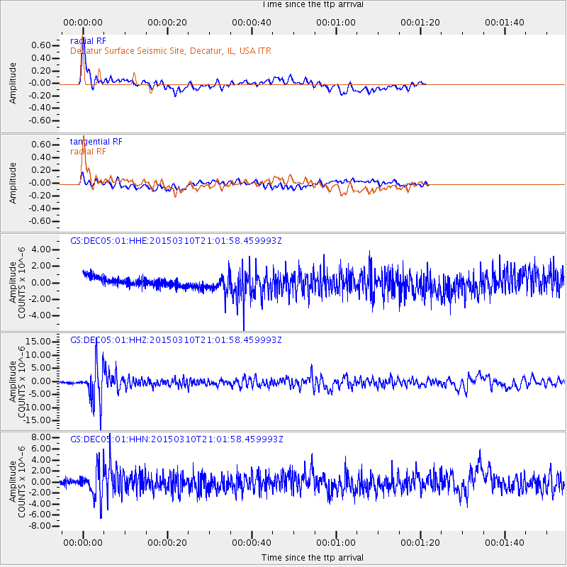
DEC05 Decatur Surface Seismic Site, Decatur, IL, USA - Earthquake Result Viewer
*The percent match for this event was below the threshold and hence no stack was calculated.
| Earthquake location: |
Northern Colombia |
| Earthquake latitude/longitude: |
6.8/-73.0 |
| Earthquake time(UTC): |
2015/03/10 (069) 20:55:43 GMT |
| Earthquake Depth: |
147 km |
| Earthquake Magnitude: |
6.2 MWB |
| Earthquake Catalog/Contributor: |
NEIC PDE/NEIC COMCAT |
|
| Network: |
GS US Geological Survey Networks |
| Station: |
DEC05 Decatur Surface Seismic Site, Decatur, IL, USA |
| Lat/Lon: |
39.87 N/88.87 W |
| Elevation: |
216 m |
|
| Distance: |
35.9 deg |
| Az: |
338.961 deg |
| Baz: |
152.405 deg |
| Ray Param: |
$rayparam |
*The percent match for this event was below the threshold and hence was not used in the summary stack. |
|
| Radial Match: |
73.362305 % |
| Radial Bump: |
400 |
| Transverse Match: |
55.04956 % |
| Transverse Bump: |
400 |
| SOD ConfigId: |
872571 |
| Insert Time: |
2015-03-24 21:11:09.521 +0000 |
| GWidth: |
2.5 |
| Max Bumps: |
400 |
| Tol: |
0.001 |
|
Signal To Noise
| Channel | StoN | STA | LTA |
| GS:DEC05:01:HHZ:20150310T21:01:58.459993Z | 36.32107 | 6.8523627E-6 | 1.8866082E-7 |
| GS:DEC05:01:HHN:20150310T21:01:58.459993Z | 5.0779443 | 2.6009295E-6 | 5.1220127E-7 |
| GS:DEC05:01:HHE:20150310T21:01:58.459993Z | 1.8986926 | 1.0066611E-6 | 5.3018647E-7 |
| Arrivals |
| Ps | |
| PpPs | |
| PsPs/PpSs | |


