You are here: Home > Network List > IU - Global Seismograph Network (GSN - IRIS/USGS) Stations List
> Station KIP Kipapa, Hawaii, USA > Earthquake Result Viewer
KIP Kipapa, Hawaii, USA - Earthquake Result Viewer
| Earthquake location: |
Near East Coast Of Kamchatka |
| Earthquake latitude/longitude: |
54.8/162.0 |
| Earthquake time(UTC): |
1997/12/05 (339) 11:26:54 GMT |
| Earthquake Depth: |
33 km |
| Earthquake Magnitude: |
6.3 MB, 7.6 MS, 7.9 UNKNOWN, 7.3 ME |
| Earthquake Catalog/Contributor: |
WHDF/NEIC |
|
| Network: |
IU Global Seismograph Network (GSN - IRIS/USGS) |
| Station: |
KIP Kipapa, Hawaii, USA |
| Lat/Lon: |
21.42 N/158.01 W |
| Elevation: |
70 m |
|
| Distance: |
44.8 deg |
| Az: |
121.914 deg |
| Baz: |
328.199 deg |
| Ray Param: |
0.07162051 |
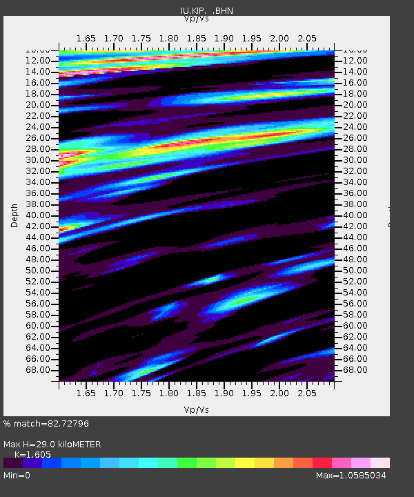
| Estimated Moho Depth: |
29.0 km |
| Estimated Crust Vp/Vs: |
1.61 |
| Assumed Crust Vp: |
4.24 km/s |
| Estimated Crust Vs: |
2.642 km/s |
| Estimated Crust Poisson's Ratio: |
0.18 |
|
| Radial Match: |
82.72796 % |
| Radial Bump: |
400 |
| Transverse Match: |
63.00508 % |
| Transverse Bump: |
355 |
| SOD ConfigId: |
4480 |
| Insert Time: |
2010-03-03 16:36:03.463 +0000 |
| GWidth: |
2.5 |
| Max Bumps: |
400 |
| Tol: |
0.001 |
|

Signal To Noise
| Channel | StoN | STA | LTA |
| IU:KIP: :BHN:19971205T11:34:34.903009Z | 2.1236176 | 8.322407E-6 | 3.918976E-6 |
| IU:KIP: :BHE:19971205T11:34:34.903009Z | 1.2378662 | 4.167099E-6 | 3.3663564E-6 |
| IU:KIP: :BHZ:19971205T11:34:34.903009Z | 0.73257565 | 4.754453E-6 | 6.4900505E-6 |
| Arrivals |
| Ps | 4.3 SECOND |
| PpPs | 17 SECOND |
| PsPs/PpSs | 22 SECOND |


