You are here: Home > Network List > IU - Global Seismograph Network (GSN - IRIS/USGS) Stations List
> Station KIP Kipapa, Hawaii, USA > Earthquake Result Viewer
KIP Kipapa, Hawaii, USA - Earthquake Result Viewer
| Earthquake location: |
Kamchatka Peninsula, Russia |
| Earthquake latitude/longitude: |
55.7/160.0 |
| Earthquake time(UTC): |
2004/06/10 (162) 15:19:57 GMT |
| Earthquake Depth: |
189 km |
| Earthquake Magnitude: |
6.1 MB, 6.9 MW, 6.9 MW |
| Earthquake Catalog/Contributor: |
WHDF/NEIC |
|
| Network: |
IU Global Seismograph Network (GSN - IRIS/USGS) |
| Station: |
KIP Kipapa, Hawaii, USA |
| Lat/Lon: |
21.42 N/158.01 W |
| Elevation: |
70 m |
|
| Distance: |
46.2 deg |
| Az: |
120.366 deg |
| Baz: |
328.367 deg |
| Ray Param: |
0.07004827 |
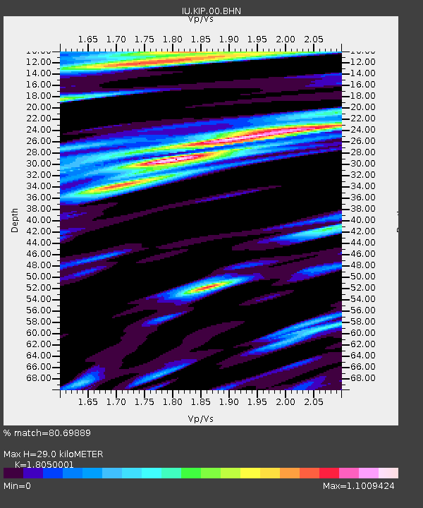
| Estimated Moho Depth: |
29.0 km |
| Estimated Crust Vp/Vs: |
1.81 |
| Assumed Crust Vp: |
4.24 km/s |
| Estimated Crust Vs: |
2.349 km/s |
| Estimated Crust Poisson's Ratio: |
0.28 |
|
| Radial Match: |
80.69889 % |
| Radial Bump: |
400 |
| Transverse Match: |
73.71163 % |
| Transverse Bump: |
400 |
| SOD ConfigId: |
2459 |
| Insert Time: |
2010-03-03 16:36:06.933 +0000 |
| GWidth: |
2.5 |
| Max Bumps: |
400 |
| Tol: |
0.001 |
|

Signal To Noise
| Channel | StoN | STA | LTA |
| IU:KIP:00:BHN:20040610T15:27:33.548004Z | 7.687944 | 5.9164045E-6 | 7.6956917E-7 |
| IU:KIP:00:BHE:20040610T15:27:33.548004Z | 6.2002835 | 4.894485E-6 | 7.8939695E-7 |
| IU:KIP:00:BHZ:20040610T15:27:33.548004Z | 12.298514 | 1.4870059E-5 | 1.2090939E-6 |
| Arrivals |
| Ps | 5.6 SECOND |
| PpPs | 19 SECOND |
| PsPs/PpSs | 24 SECOND |


