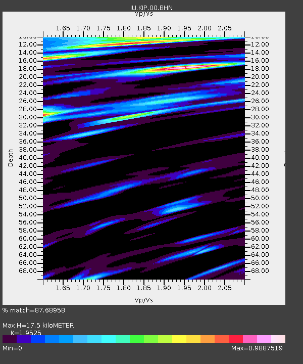
KIP Kipapa, Hawaii, USA - Earthquake Result Viewer

Earthquake location: Andreanof Islands, Aleutian Is.
Earthquake latitude/longitude: 51.4/-179.5
Earthquake time(UTC): 2007/12/19 (353) 09:30:27 GMT
Earthquake Depth: 29 km
Earthquake Magnitude: 6.4 MB, 7.1 MS, 7.1 MW, 7.0 MW
Earthquake Catalog/Contributor: WHDF/NEIC
Network: IU Global Seismograph Network (GSN - IRIS/USGS)
Station: KIP Kipapa, Hawaii, USA
Lat/Lon: 21.42 N/158.01 W
Elevation: 70 m
Distance: 34.3 deg
Az: 142.656 deg
Baz: 335.91 deg
Ray Param: 0.077778235
Estimated Moho Depth: 17.5 km
Estimated Crust Vp/Vs: 1.95
Assumed Crust Vp: 4.24 km/s
Estimated Crust Vs: 2.172 km/s
Estimated Crust Poisson's Ratio: 0.32
Radial Match: 87.68958 %
Radial Bump: 317
Transverse Match: 76.266975 %
Transverse Bump: 400
SOD ConfigId: 2564
Insert Time: 2010-03-03 16:36:09.085 +0000
GWidth: 2.5
Max Bumps: 400
Tol: 0.001

Signal To Noise

ChannelStoNSTALTA
IU:KIP:00:BHN:20071219T09:36:40.261007Z1.99122863.3363915E-61.6755442E-6
IU:KIP:00:BHE:20071219T09:36:40.261007Z1.07741241.8894375E-61.7536809E-6
IU:KIP:00:BHZ:20071219T09:36:40.261007Z3.21136785.636499E-61.7551706E-6
Arrivals
Ps4.0 SECOND
PpPs12 SECOND
PsPs/PpSs16 SECOND