You are here: Home > Network List > IU - Global Seismograph Network (GSN - IRIS/USGS) Stations List
> Station KIP Kipapa, Hawaii, USA > Earthquake Result Viewer
KIP Kipapa, Hawaii, USA - Earthquake Result Viewer
| Earthquake location: |
South Of Fiji Islands |
| Earthquake latitude/longitude: |
-26.0/-177.5 |
| Earthquake time(UTC): |
2007/12/09 (343) 07:28:20 GMT |
| Earthquake Depth: |
152 km |
| Earthquake Magnitude: |
7.0 MB, 7.8 MW, 7.7 MW |
| Earthquake Catalog/Contributor: |
WHDF/NEIC |
|
| Network: |
IU Global Seismograph Network (GSN - IRIS/USGS) |
| Station: |
KIP Kipapa, Hawaii, USA |
| Lat/Lon: |
21.42 N/158.01 W |
| Elevation: |
70 m |
|
| Distance: |
50.8 deg |
| Az: |
23.664 deg |
| Baz: |
202.811 deg |
| Ray Param: |
0.06730678 |
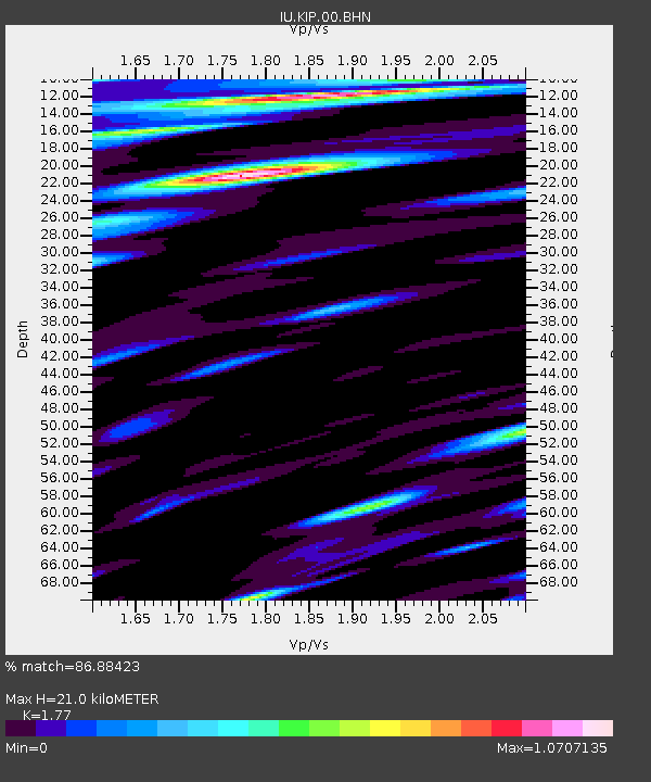
| Estimated Moho Depth: |
21.0 km |
| Estimated Crust Vp/Vs: |
1.77 |
| Assumed Crust Vp: |
4.24 km/s |
| Estimated Crust Vs: |
2.395 km/s |
| Estimated Crust Poisson's Ratio: |
0.27 |
|
| Radial Match: |
86.88423 % |
| Radial Bump: |
400 |
| Transverse Match: |
71.86961 % |
| Transverse Bump: |
400 |
| SOD ConfigId: |
2564 |
| Insert Time: |
2010-03-03 16:36:10.241 +0000 |
| GWidth: |
2.5 |
| Max Bumps: |
400 |
| Tol: |
0.001 |
|
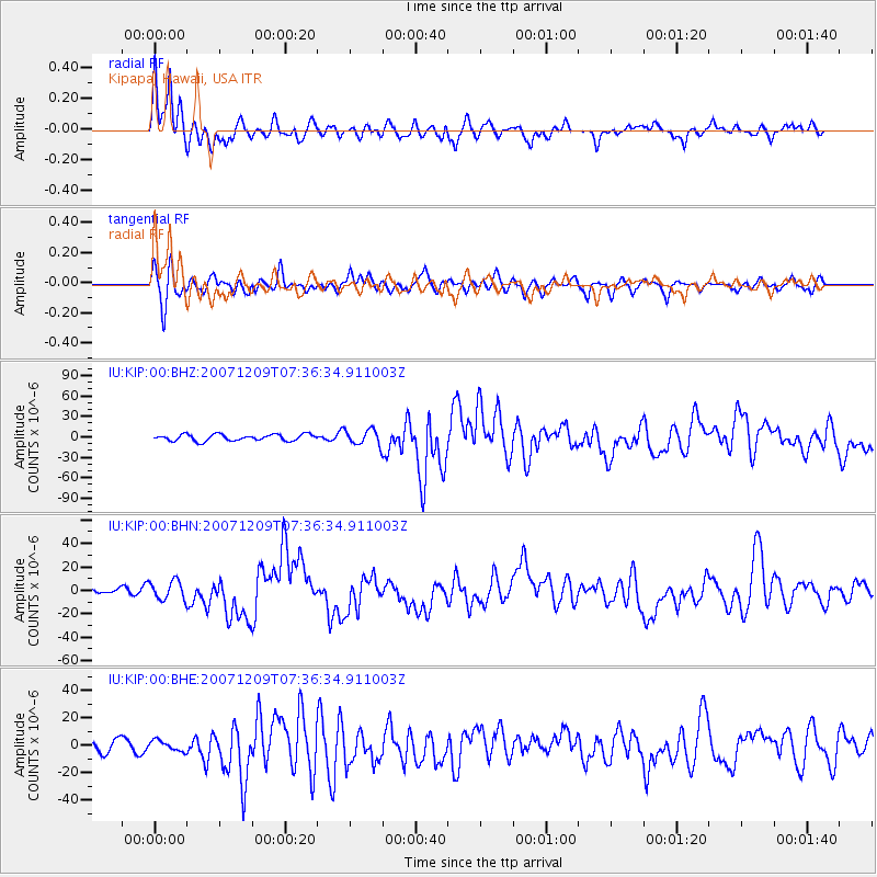
Signal To Noise
| Channel | StoN | STA | LTA |
| IU:KIP:00:BHN:20071209T07:36:34.911003Z | 2.0831077 | 8.008038E-6 | 3.8442745E-6 |
| IU:KIP:00:BHE:20071209T07:36:34.911003Z | 0.82719713 | 3.8101557E-6 | 4.6061036E-6 |
| IU:KIP:00:BHZ:20071209T07:36:34.911003Z | 2.3581412 | 1.12822145E-5 | 4.7843673E-6 |
| Arrivals |
| Ps | 3.9 SECOND |
| PpPs | 13 SECOND |
| PsPs/PpSs | 17 SECOND |


