You are here: Home > Network List > IU - Global Seismograph Network (GSN - IRIS/USGS) Stations List
> Station KIP Kipapa, Hawaii, USA > Earthquake Result Viewer
KIP Kipapa, Hawaii, USA - Earthquake Result Viewer
| Earthquake location: |
Volcano Islands, Japan Region |
| Earthquake latitude/longitude: |
22.0/142.7 |
| Earthquake time(UTC): |
2007/09/28 (271) 13:38:59 GMT |
| Earthquake Depth: |
276 km |
| Earthquake Magnitude: |
6.7 MB, 7.4 MW, 7.4 MW |
| Earthquake Catalog/Contributor: |
WHDF/NEIC |
|
| Network: |
IU Global Seismograph Network (GSN - IRIS/USGS) |
| Station: |
KIP Kipapa, Hawaii, USA |
| Lat/Lon: |
21.42 N/158.01 W |
| Elevation: |
70 m |
|
| Distance: |
54.8 deg |
| Az: |
78.712 deg |
| Baz: |
282.379 deg |
| Ray Param: |
0.06420857 |
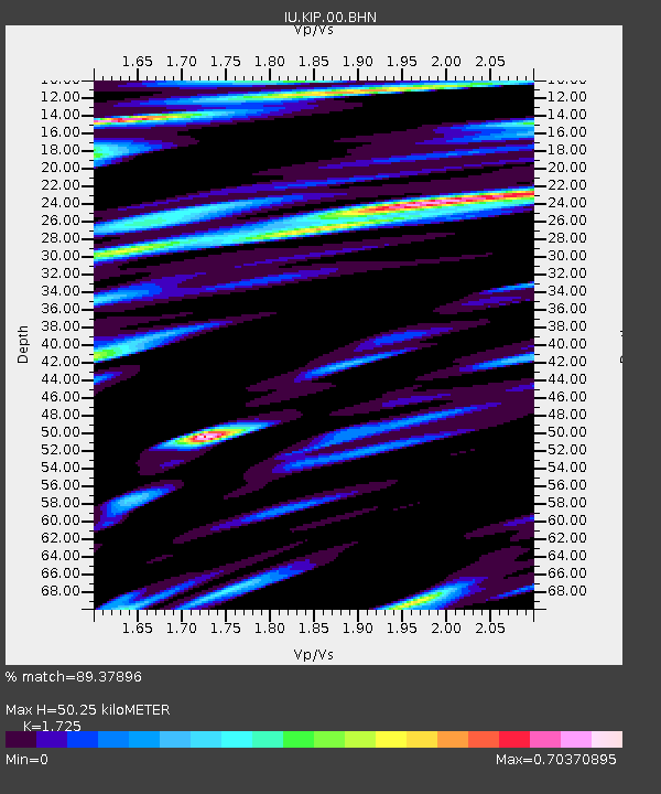
| Estimated Moho Depth: |
50.25 km |
| Estimated Crust Vp/Vs: |
1.73 |
| Assumed Crust Vp: |
4.24 km/s |
| Estimated Crust Vs: |
2.458 km/s |
| Estimated Crust Poisson's Ratio: |
0.25 |
|
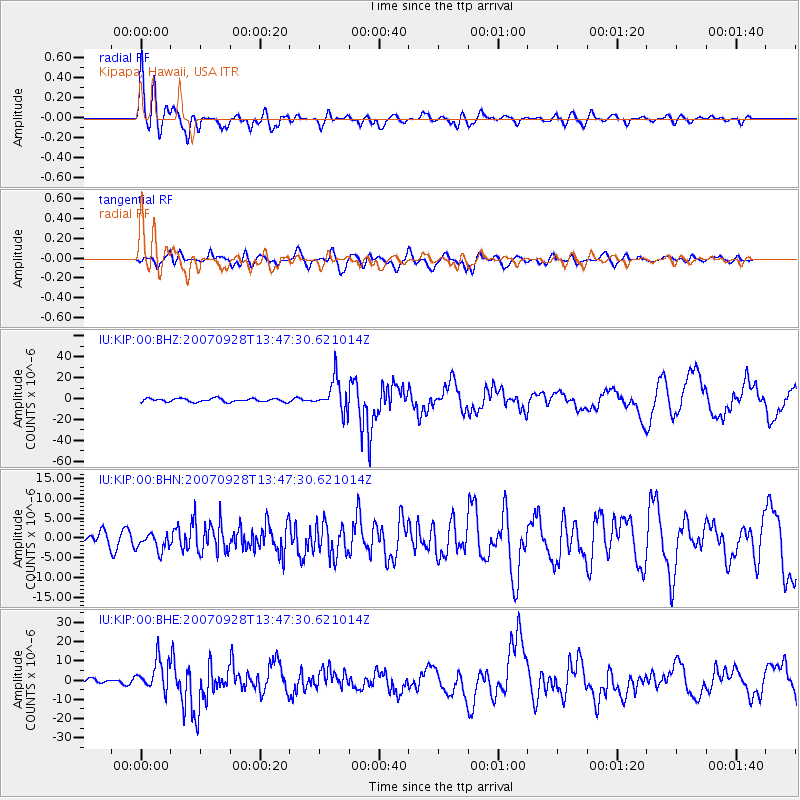
| Radial Match: |
89.37896 % |
| Radial Bump: |
400 |
| Transverse Match: |
81.16875 % |
| Transverse Bump: |
400 |
| SOD ConfigId: |
2564 |
| Insert Time: |
2010-03-03 16:36:11.202 +0000 |
| GWidth: |
2.5 |
| Max Bumps: |
400 |
| Tol: |
0.001 |
|
Signal To Noise
| Channel | StoN | STA | LTA |
| IU:KIP:00:BHN:20070928T13:47:30.621014Z | 1.9181218 | 2.2191657E-6 | 1.1569473E-6 |
| IU:KIP:00:BHE:20070928T13:47:30.621014Z | 4.948291 | 7.989313E-6 | 1.6145602E-6 |
| IU:KIP:00:BHZ:20070928T13:47:30.621014Z | 9.321808 | 1.5450254E-5 | 1.657431E-6 |
| Arrivals |
| Ps | 8.8 SECOND |
| PpPs | 32 SECOND |
| PsPs/PpSs | 40 SECOND |


