You are here: Home > Network List > UU - University of Utah Regional Network Stations List
> Station CCUT Cedar City, UT, USA > Earthquake Result Viewer
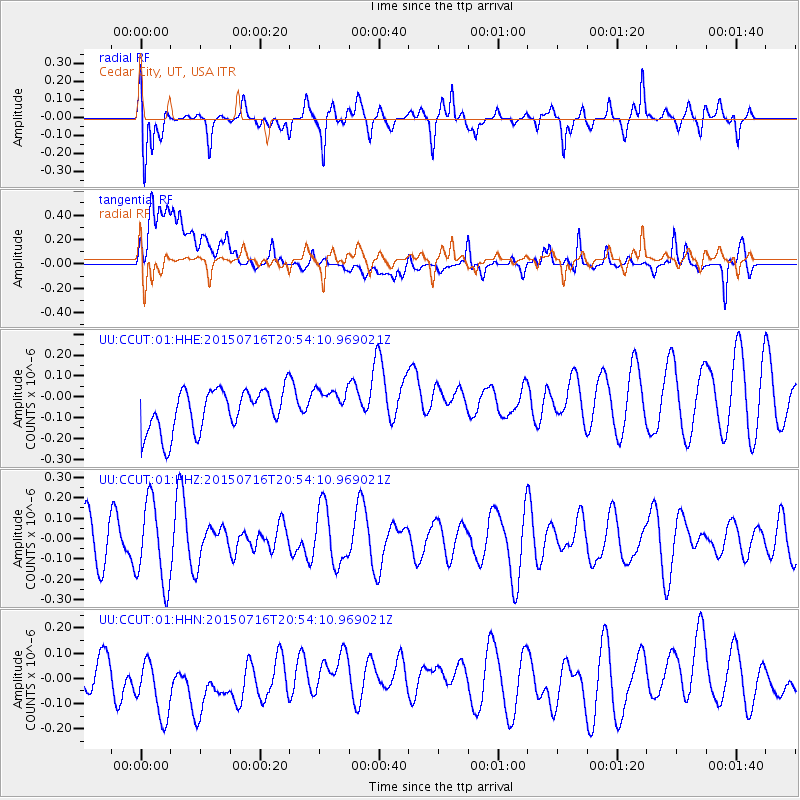
CCUT Cedar City, UT, USA - Earthquake Result Viewer
*The percent match for this event was below the threshold and hence no stack was calculated.
| Earthquake location: |
South Of Kermadec Islands |
| Earthquake latitude/longitude: |
-32.3/-177.8 |
| Earthquake time(UTC): |
2015/07/16 (197) 20:41:36 GMT |
| Earthquake Depth: |
20 km |
| Earthquake Magnitude: |
5.0 MW |
| Earthquake Catalog/Contributor: |
ISC/ISC |
|
| Network: |
UU University of Utah Regional Network |
| Station: |
CCUT Cedar City, UT, USA |
| Lat/Lon: |
37.55 N/113.36 W |
| Elevation: |
2127 m |
|
| Distance: |
91.8 deg |
| Az: |
45.824 deg |
| Baz: |
229.873 deg |
| Ray Param: |
$rayparam |
*The percent match for this event was below the threshold and hence was not used in the summary stack. |
|
| Radial Match: |
66.36861 % |
| Radial Bump: |
400 |
| Transverse Match: |
55.935524 % |
| Transverse Bump: |
400 |
| SOD ConfigId: |
7422571 |
| Insert Time: |
2019-04-19 20:27:05.630 +0000 |
| GWidth: |
2.5 |
| Max Bumps: |
400 |
| Tol: |
0.001 |
|
Signal To Noise
| Channel | StoN | STA | LTA |
| UU:CCUT:01:HHZ:20150716T20:54:10.969021Z | 1.3283473 | 2.0096144E-7 | 1.5128683E-7 |
| UU:CCUT:01:HHN:20150716T20:54:10.969021Z | 1.2990261 | 1.5095257E-7 | 1.1620441E-7 |
| UU:CCUT:01:HHE:20150716T20:54:10.969021Z | 0.8186433 | 8.305114E-8 | 1.0144973E-7 |
| Arrivals |
| Ps | |
| PpPs | |
| PsPs/PpSs | |


