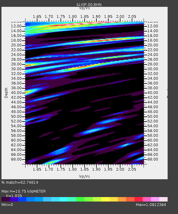
KIP Kipapa, Hawaii, USA - Earthquake Result Viewer
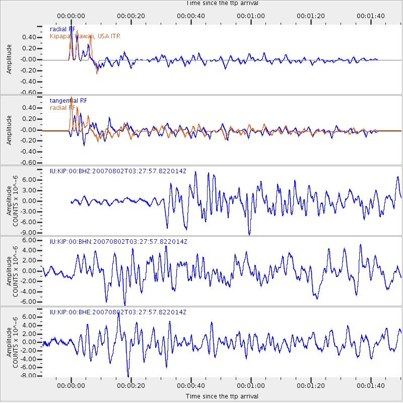
Earthquake location: Andreanof Islands, Aleutian Is.
Earthquake latitude/longitude: 51.3/-180.0
Earthquake time(UTC): 2007/08/02 (214) 03:21:42 GMT
Earthquake Depth: 21 km
Earthquake Magnitude: 6.3 MB, 6.6 MS, 6.7 MW, 6.6 MW
Earthquake Catalog/Contributor: WHDF/NEIC
Network: IU Global Seismograph Network (GSN - IRIS/USGS)
Station: KIP Kipapa, Hawaii, USA
Lat/Lon: 21.42 N/158.01 W
Elevation: 70 m
Distance: 34.4 deg
Az: 141.93 deg
Baz: 335.454 deg
Ray Param: 0.07773522
Estimated Moho Depth: 10.75 km
Estimated Crust Vp/Vs: 1.84
Assumed Crust Vp: 4.24 km/s
Estimated Crust Vs: 2.311 km/s
Estimated Crust Poisson's Ratio: 0.29
Radial Match: 82.74814 %
Radial Bump: 298
Transverse Match: 83.84324 %
Transverse Bump: 392
SOD ConfigId: 2564
Insert Time: 2010-03-03 16:36:15.041 +0000
GWidth: 2.5
Max Bumps: 400
Tol: 0.001

Signal To Noise

ChannelStoNSTALTA
IU:KIP:00:BHN:20070802T03:27:57.822014Z4.36613461.8092379E-64.1437977E-7
IU:KIP:00:BHE:20070802T03:27:57.822014Z2.01497941.5171976E-67.5295935E-7
IU:KIP:00:BHZ:20070802T03:27:57.822014Z5.6179643.0437743E-65.4179316E-7
Arrivals
Ps2.2 SECOND
PpPs7.0 SECOND
PsPs/PpSs9.2 SECOND