You are here: Home > Network List > IU - Global Seismograph Network (GSN - IRIS/USGS) Stations List
> Station KIP Kipapa, Hawaii, USA > Earthquake Result Viewer
KIP Kipapa, Hawaii, USA - Earthquake Result Viewer
| Earthquake location: |
Sea Of Japan |
| Earthquake latitude/longitude: |
36.8/134.9 |
| Earthquake time(UTC): |
2007/07/16 (197) 14:17:37 GMT |
| Earthquake Depth: |
350 km |
| Earthquake Magnitude: |
6.2 MB, 6.8 MW, 6.8 MW |
| Earthquake Catalog/Contributor: |
WHDF/NEIC |
|
| Network: |
IU Global Seismograph Network (GSN - IRIS/USGS) |
| Station: |
KIP Kipapa, Hawaii, USA |
| Lat/Lon: |
21.42 N/158.01 W |
| Elevation: |
70 m |
|
| Distance: |
59.5 deg |
| Az: |
84.976 deg |
| Baz: |
300.9 deg |
| Ray Param: |
0.06089001 |
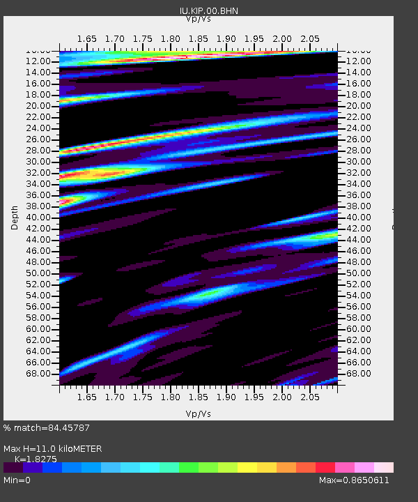
| Estimated Moho Depth: |
11.0 km |
| Estimated Crust Vp/Vs: |
1.83 |
| Assumed Crust Vp: |
4.24 km/s |
| Estimated Crust Vs: |
2.32 km/s |
| Estimated Crust Poisson's Ratio: |
0.29 |
|
| Radial Match: |
84.45787 % |
| Radial Bump: |
400 |
| Transverse Match: |
66.69191 % |
| Transverse Bump: |
400 |
| SOD ConfigId: |
2564 |
| Insert Time: |
2010-03-03 16:36:18.735 +0000 |
| GWidth: |
2.5 |
| Max Bumps: |
400 |
| Tol: |
0.001 |
|
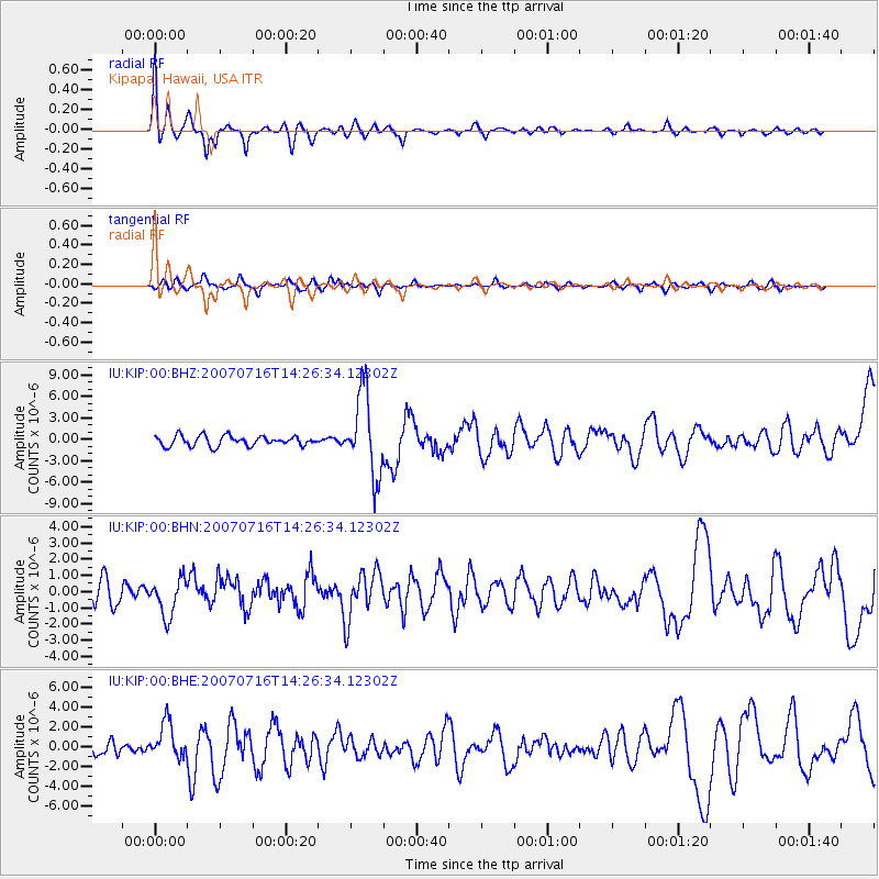
Signal To Noise
| Channel | StoN | STA | LTA |
| IU:KIP:00:BHN:20070716T14:26:34.12302Z | 1.4278159 | 1.166586E-6 | 8.1704235E-7 |
| IU:KIP:00:BHE:20070716T14:26:34.12302Z | 1.8107494 | 1.8007909E-6 | 9.945003E-7 |
| IU:KIP:00:BHZ:20070716T14:26:34.12302Z | 7.984122 | 5.6450835E-6 | 7.0703874E-7 |
| Arrivals |
| Ps | 2.2 SECOND |
| PpPs | 7.2 SECOND |
| PsPs/PpSs | 9.4 SECOND |


