You are here: Home > Network List > GS - US Geological Survey Networks Stations List
> Station KAN11 Stewart Ranch, Harper County, KS, USA > Earthquake Result Viewer
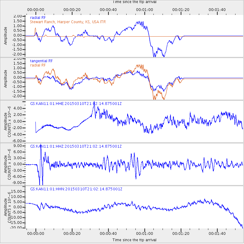
KAN11 Stewart Ranch, Harper County, KS, USA - Earthquake Result Viewer
*The percent match for this event was below the threshold and hence no stack was calculated.
| Earthquake location: |
Northern Colombia |
| Earthquake latitude/longitude: |
6.8/-73.0 |
| Earthquake time(UTC): |
2015/03/10 (069) 20:55:43 GMT |
| Earthquake Depth: |
147 km |
| Earthquake Magnitude: |
6.2 MWB |
| Earthquake Catalog/Contributor: |
NEIC PDE/NEIC COMCAT |
|
| Network: |
GS US Geological Survey Networks |
| Station: |
KAN11 Stewart Ranch, Harper County, KS, USA |
| Lat/Lon: |
37.21 N/97.91 W |
| Elevation: |
410 m |
|
| Distance: |
37.8 deg |
| Az: |
326.73 deg |
| Baz: |
136.978 deg |
| Ray Param: |
$rayparam |
*The percent match for this event was below the threshold and hence was not used in the summary stack. |
|
| Radial Match: |
39.243996 % |
| Radial Bump: |
400 |
| Transverse Match: |
32.30505 % |
| Transverse Bump: |
400 |
| SOD ConfigId: |
872571 |
| Insert Time: |
2015-03-24 21:12:04.685 +0000 |
| GWidth: |
2.5 |
| Max Bumps: |
400 |
| Tol: |
0.001 |
|
Signal To Noise
| Channel | StoN | STA | LTA |
| GS:KAN11:01:HHZ:20150310T21:02:14.875001Z | 32.26861 | 4.6383657E-6 | 1.4374235E-7 |
| GS:KAN11:01:HHN:20150310T21:02:14.875001Z | 0.8012621 | 5.3003864E-6 | 6.615047E-6 |
| GS:KAN11:01:HHE:20150310T21:02:14.875001Z | 8.46674 | 4.8971015E-6 | 5.783928E-7 |
| Arrivals |
| Ps | |
| PpPs | |
| PsPs/PpSs | |


