You are here: Home > Network List > IU - Global Seismograph Network (GSN - IRIS/USGS) Stations List
> Station KIP Kipapa, Hawaii, USA > Earthquake Result Viewer
KIP Kipapa, Hawaii, USA - Earthquake Result Viewer
| Earthquake location: |
Sakhalin, Russia |
| Earthquake latitude/longitude: |
49.0/141.9 |
| Earthquake time(UTC): |
1990/05/12 (132) 04:50:09 GMT |
| Earthquake Depth: |
611 km |
| Earthquake Magnitude: |
6.4 MB |
| Earthquake Catalog/Contributor: |
WHDF/NEIC |
|
| Network: |
IU Global Seismograph Network (GSN - IRIS/USGS) |
| Station: |
KIP Kipapa, Hawaii, USA |
| Lat/Lon: |
21.42 N/158.01 W |
| Elevation: |
70 m |
|
| Distance: |
54.6 deg |
| Az: |
97.806 deg |
| Baz: |
315.596 deg |
| Ray Param: |
0.0626494 |
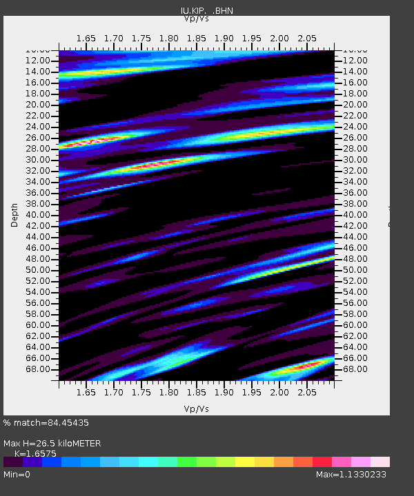
| Estimated Moho Depth: |
26.5 km |
| Estimated Crust Vp/Vs: |
1.66 |
| Assumed Crust Vp: |
4.24 km/s |
| Estimated Crust Vs: |
2.558 km/s |
| Estimated Crust Poisson's Ratio: |
0.21 |
|
| Radial Match: |
84.45435 % |
| Radial Bump: |
400 |
| Transverse Match: |
87.68958 % |
| Transverse Bump: |
400 |
| SOD ConfigId: |
16938 |
| Insert Time: |
2010-03-03 16:36:31.111 +0000 |
| GWidth: |
2.5 |
| Max Bumps: |
400 |
| Tol: |
0.001 |
|

Signal To Noise
| Channel | StoN | STA | LTA |
| IU:KIP: :BHN:19900512T04:58:10.96701Z | 7.9475155 | 6.743949E-6 | 8.4856066E-7 |
| IU:KIP: :BHE:19900512T04:58:10.96701Z | 11.359116 | 9.54352E-6 | 8.40164E-7 |
| IU:KIP: :BHZ:19900512T04:58:10.96701Z | 18.431978 | 2.0878873E-5 | 1.1327528E-6 |
| Arrivals |
| Ps | 4.2 SECOND |
| PpPs | 16 SECOND |
| PsPs/PpSs | 20 SECOND |


