You are here: Home > Network List > IU - Global Seismograph Network (GSN - IRIS/USGS) Stations List
> Station KIP Kipapa, Hawaii, USA > Earthquake Result Viewer
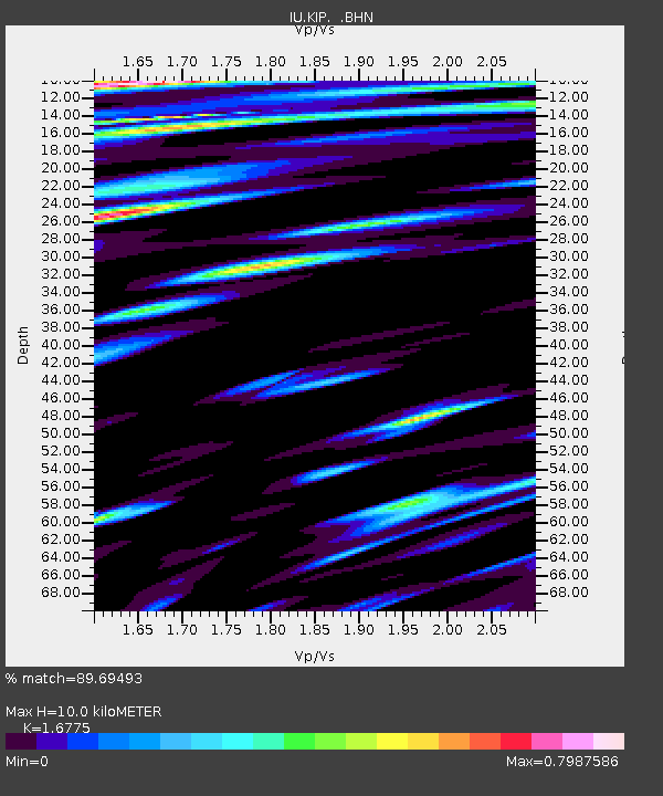
KIP Kipapa, Hawaii, USA - Earthquake Result Viewer
| Earthquake location: |
Vanuatu Islands |
| Earthquake latitude/longitude: |
-15.3/167.4 |
| Earthquake time(UTC): |
1990/07/27 (208) 12:38:00 GMT |
| Earthquake Depth: |
133 km |
| Earthquake Magnitude: |
6.4 MB, 6.8 MS, 6.9 UNKNOWN |
| Earthquake Catalog/Contributor: |
WHDF/NEIC |
|
| Network: |
IU Global Seismograph Network (GSN - IRIS/USGS) |
| Station: |
KIP Kipapa, Hawaii, USA |
| Lat/Lon: |
21.42 N/158.01 W |
| Elevation: |
70 m |
|
| Distance: |
49.8 deg |
| Az: |
43.789 deg |
| Baz: |
225.778 deg |
| Ray Param: |
0.06798175 |
| Estimated Moho Depth: |
10.0 km |
| Estimated Crust Vp/Vs: |
1.68 |
| Assumed Crust Vp: |
4.24 km/s |
| Estimated Crust Vs: |
2.528 km/s |
| Estimated Crust Poisson's Ratio: |
0.22 |
|
| Radial Match: |
89.69493 % |
| Radial Bump: |
400 |
| Transverse Match: |
88.16613 % |
| Transverse Bump: |
400 |
| SOD ConfigId: |
16938 |
| Insert Time: |
2010-03-03 16:36:32.430 +0000 |
| GWidth: |
2.5 |
| Max Bumps: |
400 |
| Tol: |
0.001 |
|

Signal To Noise
| Channel | StoN | STA | LTA |
| IU:KIP: :BHN:19900727T12:46:09.549988Z | 3.643017 | 2.5908105E-6 | 7.1117165E-7 |
| IU:KIP: :BHE:19900727T12:46:09.549988Z | 5.3478084 | 4.534476E-6 | 8.4791293E-7 |
| IU:KIP: :BHZ:19900727T12:46:09.549988Z | 8.016108 | 9.4876395E-6 | 1.183572E-6 |
| Arrivals |
| Ps | 1.6 SECOND |
| PpPs | 6.2 SECOND |
| PsPs/PpSs | 7.8 SECOND |


