You are here: Home > Network List > IU - Global Seismograph Network (GSN - IRIS/USGS) Stations List
> Station KIP Kipapa, Hawaii, USA > Earthquake Result Viewer
KIP Kipapa, Hawaii, USA - Earthquake Result Viewer

| Earthquake location: |
Vanuatu Islands |
| Earthquake latitude/longitude: |
-19.4/169.1 |
| Earthquake time(UTC): |
1990/08/12 (224) 21:25:22 GMT |
| Earthquake Depth: |
144 km |
| Earthquake Magnitude: |
6.4 MB |
| Earthquake Catalog/Contributor: |
WHDF/NEIC |
|
| Network: |
IU Global Seismograph Network (GSN - IRIS/USGS) |
| Station: |
KIP Kipapa, Hawaii, USA |
| Lat/Lon: |
21.42 N/158.01 W |
| Elevation: |
70 m |
|
| Distance: |
51.8 deg |
| Az: |
40.118 deg |
| Baz: |
220.746 deg |
| Ray Param: |
0.066670336 |
| Estimated Moho Depth: |
64.5 km |
| Estimated Crust Vp/Vs: |
1.83 |
| Assumed Crust Vp: |
4.24 km/s |
| Estimated Crust Vs: |
2.32 km/s |
| Estimated Crust Poisson's Ratio: |
0.29 |
|
| Radial Match: |
90.2588 % |
| Radial Bump: |
400 |
| Transverse Match: |
81.359055 % |
| Transverse Bump: |
400 |
| SOD ConfigId: |
16938 |
| Insert Time: |
2010-03-03 16:36:36.181 +0000 |
| GWidth: |
2.5 |
| Max Bumps: |
400 |
| Tol: |
0.001 |
|
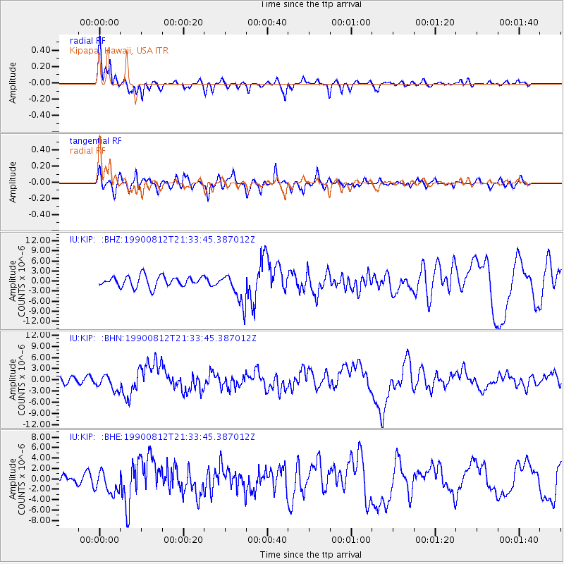
Signal To Noise
| Channel | StoN | STA | LTA |
| IU:KIP: :BHN:19900812T21:33:45.387012Z | 2.0192232 | 2.0493537E-6 | 1.0149218E-6 |
| IU:KIP: :BHE:19900812T21:33:45.387012Z | 2.2350307 | 2.14478E-6 | 9.596199E-7 |
| IU:KIP: :BHZ:19900812T21:33:45.387012Z | 3.099963 | 4.950192E-6 | 1.5968551E-6 |
| Arrivals |
| Ps | 13 SECOND |
| PpPs | 42 SECOND |
| PsPs/PpSs | 55 SECOND |


