You are here: Home > Network List > IU - Global Seismograph Network (GSN - IRIS/USGS) Stations List
> Station KIP Kipapa, Hawaii, USA > Earthquake Result Viewer
KIP Kipapa, Hawaii, USA - Earthquake Result Viewer
| Earthquake location: |
New Britain Region, P.N.G. |
| Earthquake latitude/longitude: |
-5.1/151.0 |
| Earthquake time(UTC): |
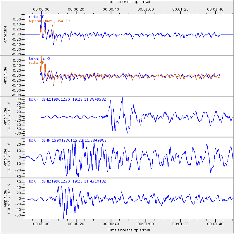
1990/12/30 (364) 19:14:19 GMT |
| Earthquake Depth: |
188 km |
| Earthquake Magnitude: |
6.7 MB, 7.0 MS |
| Earthquake Catalog/Contributor: |
WHDF/NEIC |
|
| Network: |
IU Global Seismograph Network (GSN - IRIS/USGS) |
| Station: |
KIP Kipapa, Hawaii, USA |
| Lat/Lon: |
21.42 N/158.01 W |
| Elevation: |
70 m |
|
| Distance: |
56.5 deg |
| Az: |
60.278 deg |
| Baz: |
248.193 deg |
| Ray Param: |
0.06348444 |
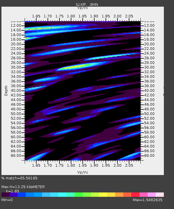
| Estimated Moho Depth: |
13.25 km |
| Estimated Crust Vp/Vs: |
1.65 |
| Assumed Crust Vp: |
4.24 km/s |
| Estimated Crust Vs: |
2.57 km/s |
| Estimated Crust Poisson's Ratio: |
0.21 |
|
| Radial Match: |
85.58165 % |
| Radial Bump: |
400 |
| Transverse Match: |
69.80679 % |
| Transverse Bump: |
400 |
| SOD ConfigId: |
16938 |
| Insert Time: |
2010-03-03 16:36:37.499 +0000 |
| GWidth: |
2.5 |
| Max Bumps: |
400 |
| Tol: |
0.001 |
|
Signal To Noise
| Channel | StoN | STA | LTA |
| IU:KIP: :BHN:19901230T19:23:11.384998Z | 2.9856095 | 6.8603795E-6 | 2.2978156E-6 |
| IU:KIP: :BHE:19901230T19:23:11.431018Z | 0.9253996 | 4.789823E-6 | 5.175951E-6 |
| IU:KIP: :BHZ:19901230T19:23:11.384998Z | 0.5276529 | 2.0552684E-6 | 3.8951143E-6 |
| Arrivals |
| Ps | 2.1 SECOND |
| PpPs | 8.1 SECOND |
| PsPs/PpSs | 10 SECOND |


