You are here: Home > Network List > IU - Global Seismograph Network (GSN - IRIS/USGS) Stations List
> Station KIP Kipapa, Hawaii, USA > Earthquake Result Viewer
KIP Kipapa, Hawaii, USA - Earthquake Result Viewer

| Earthquake location: |
Off Coast Of Northern California |
| Earthquake latitude/longitude: |
41.6/-125.5 |
| Earthquake time(UTC): |
1991/08/17 (229) 22:17:12 GMT |
| Earthquake Depth: |
10 km |
| Earthquake Magnitude: |
6.2 MB, 7.1 MS, 6.8 ML |
| Earthquake Catalog/Contributor: |
WHDF/NEIC |
|
| Network: |
IU Global Seismograph Network (GSN - IRIS/USGS) |
| Station: |
KIP Kipapa, Hawaii, USA |
| Lat/Lon: |
21.42 N/158.01 W |
| Elevation: |
70 m |
|
| Distance: |
34.0 deg |
| Az: |
243.703 deg |
| Baz: |
46.186 deg |
| Ray Param: |
0.0779693 |
| Estimated Moho Depth: |
11.25 km |
| Estimated Crust Vp/Vs: |
1.88 |
| Assumed Crust Vp: |
4.24 km/s |
| Estimated Crust Vs: |
2.249 km/s |
| Estimated Crust Poisson's Ratio: |
0.30 |
|
| Radial Match: |
89.80266 % |
| Radial Bump: |
400 |
| Transverse Match: |
76.94045 % |
| Transverse Bump: |
400 |
| SOD ConfigId: |
16938 |
| Insert Time: |
2010-03-03 16:36:40.543 +0000 |
| GWidth: |
2.5 |
| Max Bumps: |
400 |
| Tol: |
0.001 |
|
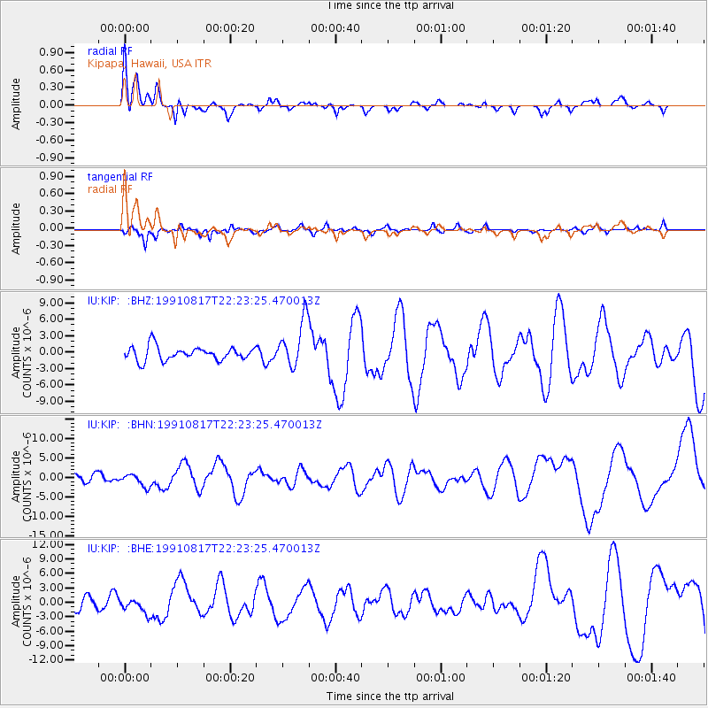
Signal To Noise
| Channel | StoN | STA | LTA |
| IU:KIP: :BHN:19910817T22:23:25.470013Z | 1.2718688 | 1.6543232E-6 | 1.3007027E-6 |
| IU:KIP: :BHE:19910817T22:23:25.470013Z | 1.0970813 | 1.6211411E-6 | 1.4776855E-6 |
| IU:KIP: :BHZ:19910817T22:23:25.470013Z | 3.5295038 | 4.3991417E-6 | 1.246391E-6 |
| Arrivals |
| Ps | 2.4 SECOND |
| PpPs | 7.4 SECOND |
| PsPs/PpSs | 9.8 SECOND |


