You are here: Home > Network List > IU - Global Seismograph Network (GSN - IRIS/USGS) Stations List
> Station KIP Kipapa, Hawaii, USA > Earthquake Result Viewer
KIP Kipapa, Hawaii, USA - Earthquake Result Viewer

| Earthquake location: |
Hokkaido, Japan Region |
| Earthquake latitude/longitude: |
43.0/144.2 |
| Earthquake time(UTC): |
1993/01/15 (015) 11:06:00 GMT |
| Earthquake Depth: |
100 km |
| Earthquake Magnitude: |
6.0 MB |
| Earthquake Catalog/Contributor: |
WHDF/NEIC |
|
| Network: |
IU Global Seismograph Network (GSN - IRIS/USGS) |
| Station: |
KIP Kipapa, Hawaii, USA |
| Lat/Lon: |
21.42 N/158.01 W |
| Elevation: |
70 m |
|
| Distance: |
52.3 deg |
| Az: |
95.134 deg |
| Baz: |
308.332 deg |
| Ray Param: |
0.06651634 |
| Estimated Moho Depth: |
15.25 km |
| Estimated Crust Vp/Vs: |
1.60 |
| Assumed Crust Vp: |
4.24 km/s |
| Estimated Crust Vs: |
2.65 km/s |
| Estimated Crust Poisson's Ratio: |
0.18 |
|
| Radial Match: |
86.9711 % |
| Radial Bump: |
400 |
| Transverse Match: |
76.375046 % |
| Transverse Bump: |
400 |
| SOD ConfigId: |
16938 |
| Insert Time: |
2010-03-03 16:36:52.165 +0000 |
| GWidth: |
2.5 |
| Max Bumps: |
400 |
| Tol: |
0.001 |
|
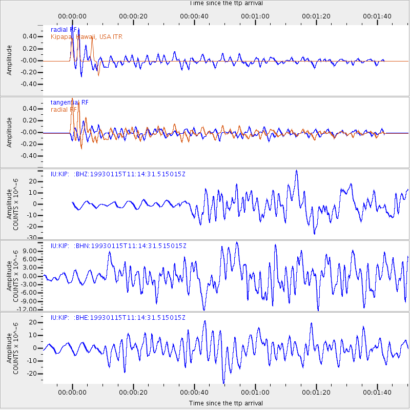
Signal To Noise
| Channel | StoN | STA | LTA |
| IU:KIP: :BHN:19930115T11:14:31.515015Z | 1.2377766 | 1.7790006E-6 | 1.437255E-6 |
| IU:KIP: :BHE:19930115T11:14:31.515015Z | 2.0657609 | 3.1834552E-6 | 1.541057E-6 |
| IU:KIP: :BHZ:19930115T11:14:31.515015Z | 0.94293195 | 2.0868151E-6 | 2.2131132E-6 |
| Arrivals |
| Ps | 2.2 SECOND |
| PpPs | 9.1 SECOND |
| PsPs/PpSs | 11 SECOND |


