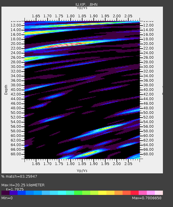
KIP Kipapa, Hawaii, USA - Earthquake Result Viewer

Earthquake location: Off W. Coast Of S. Island, N.Z.
Earthquake latitude/longitude: -45.1/167.0
Earthquake time(UTC): 1993/08/10 (222) 00:51:54 GMT
Earthquake Depth: 33 km
Earthquake Magnitude: 6.2 MB, 7.1 MS, 7.1 UNKNOWN, 7.0 MW
Earthquake Catalog/Contributor: WHDF/NEIC
Network: IU Global Seismograph Network (GSN - IRIS/USGS)
Station: KIP Kipapa, Hawaii, USA
Lat/Lon: 21.42 N/158.01 W
Elevation: 70 m
Distance: 73.5 deg
Az: 33.897 deg
Baz: 205.064 deg
Ray Param: 0.052891616
Estimated Moho Depth: 20.25 km
Estimated Crust Vp/Vs: 1.78
Assumed Crust Vp: 4.24 km/s
Estimated Crust Vs: 2.379 km/s
Estimated Crust Poisson's Ratio: 0.27
Radial Match: 83.25947 %
Radial Bump: 400
Transverse Match: 83.26646 %
Transverse Bump: 400
SOD ConfigId: 16938
Insert Time: 2010-03-03 16:36:53.805 +0000
GWidth: 2.5
Max Bumps: 400
Tol: 0.001

Signal To Noise

ChannelStoNSTALTA
IU:KIP: :BHN:19930810T01:02:53.267017Z1.2417996.1226234E-74.9304464E-7
IU:KIP: :BHE:19930810T01:02:53.267017Z0.819829348.84806E-101.0792564E-9
IU:KIP: :BHZ:19930810T01:02:53.267017Z2.43057682.1328085E-68.774907E-7
Arrivals
Ps3.8 SECOND
PpPs13 SECOND
PsPs/PpSs17 SECOND