You are here: Home > Network List > IU - Global Seismograph Network (GSN - IRIS/USGS) Stations List
> Station KIP Kipapa, Hawaii, USA > Earthquake Result Viewer
KIP Kipapa, Hawaii, USA - Earthquake Result Viewer
| Earthquake location: |
Tonga Islands |
| Earthquake latitude/longitude: |
-15.2/-173.6 |
| Earthquake time(UTC): |
1995/04/07 (097) 22:06:58 GMT |
| Earthquake Depth: |
31 km |
| Earthquake Magnitude: |
6.7 MB, 8.0 MS, 7.5 UNKNOWN, 7.1 MD |
| Earthquake Catalog/Contributor: |
WHDF/NEIC |
|
| Network: |
IU Global Seismograph Network (GSN - IRIS/USGS) |
| Station: |
KIP Kipapa, Hawaii, USA |
| Lat/Lon: |
21.42 N/158.01 W |
| Elevation: |
70 m |
|
| Distance: |
39.5 deg |
| Az: |
23.185 deg |
| Baz: |
204.078 deg |
| Ray Param: |
0.07491177 |
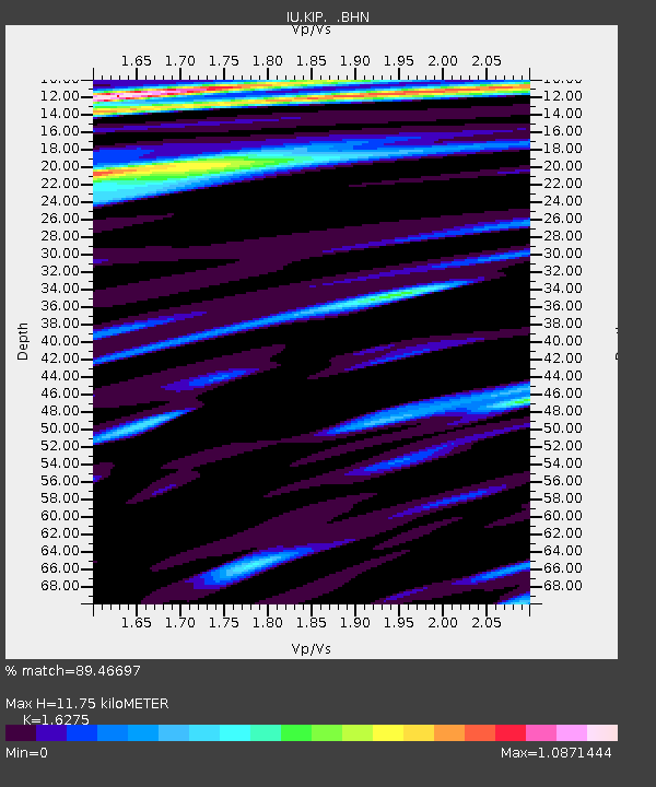
| Estimated Moho Depth: |
11.75 km |
| Estimated Crust Vp/Vs: |
1.63 |
| Assumed Crust Vp: |
4.24 km/s |
| Estimated Crust Vs: |
2.605 km/s |
| Estimated Crust Poisson's Ratio: |
0.20 |
|
| Radial Match: |
89.46697 % |
| Radial Bump: |
400 |
| Transverse Match: |
81.98167 % |
| Transverse Bump: |
400 |
| SOD ConfigId: |
6273 |
| Insert Time: |
2010-03-03 16:36:58.985 +0000 |
| GWidth: |
2.5 |
| Max Bumps: |
400 |
| Tol: |
0.001 |
|
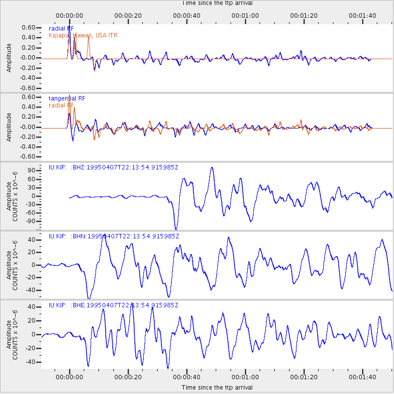
Signal To Noise
| Channel | StoN | STA | LTA |
| IU:KIP: :BHN:19950407T22:13:54.915985Z | 2.4231732 | 3.833877E-6 | 1.5821722E-6 |
| IU:KIP: :BHE:19950407T22:13:54.915985Z | 1.565233 | 3.4773918E-6 | 2.221645E-6 |
| IU:KIP: :BHZ:19950407T22:13:54.915985Z | 3.2886503 | 8.502543E-6 | 2.5854204E-6 |
| Arrivals |
| Ps | 1.8 SECOND |
| PpPs | 7.1 SECOND |
| PsPs/PpSs | 8.8 SECOND |


