You are here: Home > Network List > IU - Global Seismograph Network (GSN - IRIS/USGS) Stations List
> Station KIP Kipapa, Hawaii, USA > Earthquake Result Viewer
KIP Kipapa, Hawaii, USA - Earthquake Result Viewer
| Earthquake location: |
Solomon Islands |
| Earthquake latitude/longitude: |
-5.8/154.3 |
| Earthquake time(UTC): |
1995/08/16 (228) 23:10:28 GMT |
| Earthquake Depth: |
74 km |
| Earthquake Magnitude: |
6.1 MB, 7.2 MS, 7.2 UNKNOWN, 7.2 MW |
| Earthquake Catalog/Contributor: |
WHDF/NEIC |
|
| Network: |
IU Global Seismograph Network (GSN - IRIS/USGS) |
| Station: |
KIP Kipapa, Hawaii, USA |
| Lat/Lon: |
21.42 N/158.01 W |
| Elevation: |
70 m |
|
| Distance: |
54.0 deg |
| Az: |
58.408 deg |
| Baz: |
245.452 deg |
| Ray Param: |
0.06549537 |
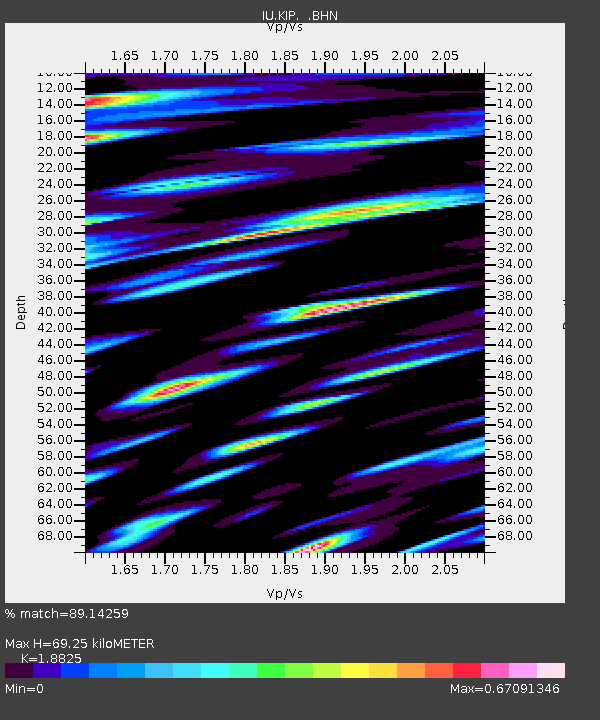
| Estimated Moho Depth: |
69.25 km |
| Estimated Crust Vp/Vs: |
1.88 |
| Assumed Crust Vp: |
4.24 km/s |
| Estimated Crust Vs: |
2.252 km/s |
| Estimated Crust Poisson's Ratio: |
0.30 |
|
| Radial Match: |
89.14259 % |
| Radial Bump: |
400 |
| Transverse Match: |
77.01166 % |
| Transverse Bump: |
400 |
| SOD ConfigId: |
6273 |
| Insert Time: |
2010-03-03 16:37:03.294 +0000 |
| GWidth: |
2.5 |
| Max Bumps: |
400 |
| Tol: |
0.001 |
|
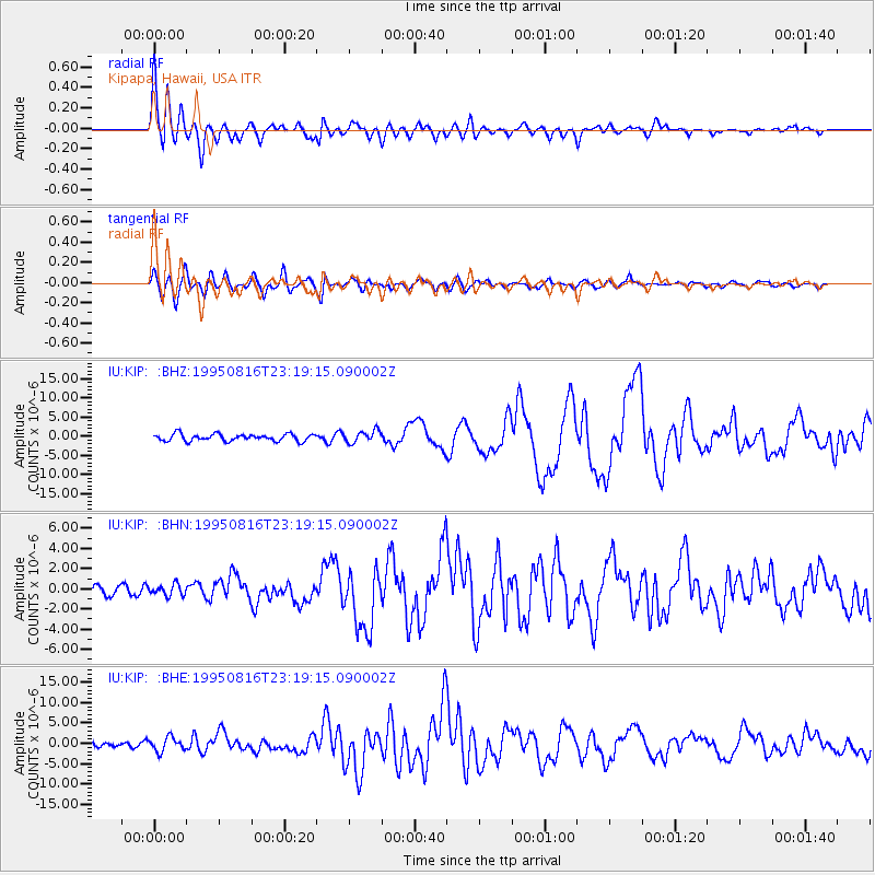
Signal To Noise
| Channel | StoN | STA | LTA |
| IU:KIP: :BHN:19950816T23:19:15.090002Z | 0.92858225 | 5.4212427E-7 | 5.8381937E-7 |
| IU:KIP: :BHE:19950816T23:19:15.090002Z | 2.4782693 | 1.7242724E-6 | 6.957567E-7 |
| IU:KIP: :BHZ:19950816T23:19:15.090002Z | 1.7302796 | 1.5790771E-6 | 9.126139E-7 |
| Arrivals |
| Ps | 15 SECOND |
| PpPs | 46 SECOND |
| PsPs/PpSs | 61 SECOND |


