You are here: Home > Network List > IU - Global Seismograph Network (GSN - IRIS/USGS) Stations List
> Station KIP Kipapa, Hawaii, USA > Earthquake Result Viewer
KIP Kipapa, Hawaii, USA - Earthquake Result Viewer
| Earthquake location: |
Near S. Coast Of Honshu, Japan |
| Earthquake latitude/longitude: |
33.2/137.9 |
| Earthquake time(UTC): |
2009/08/09 (221) 10:55:55 GMT |
| Earthquake Depth: |
297 km |
| Earthquake Magnitude: |
6.5 MB, 7.1 MW, 7.1 MW |
| Earthquake Catalog/Contributor: |
WHDF/NEIC |
|
| Network: |
IU Global Seismograph Network (GSN - IRIS/USGS) |
| Station: |
KIP Kipapa, Hawaii, USA |
| Lat/Lon: |
21.42 N/158.01 W |
| Elevation: |
110 m |
|
| Distance: |
57.3 deg |
| Az: |
84.375 deg |
| Baz: |
296.382 deg |
| Ray Param: |
0.06251728 |
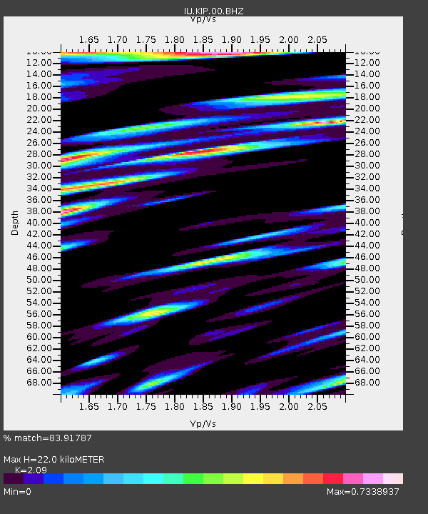
| Estimated Moho Depth: |
22.0 km |
| Estimated Crust Vp/Vs: |
2.09 |
| Assumed Crust Vp: |
4.24 km/s |
| Estimated Crust Vs: |
2.029 km/s |
| Estimated Crust Poisson's Ratio: |
0.35 |
|
| Radial Match: |
83.91787 % |
| Radial Bump: |
400 |
| Transverse Match: |
74.471855 % |
| Transverse Bump: |
400 |
| SOD ConfigId: |
2622 |
| Insert Time: |
2010-03-03 16:37:11.011 +0000 |
| GWidth: |
2.5 |
| Max Bumps: |
400 |
| Tol: |
0.001 |
|
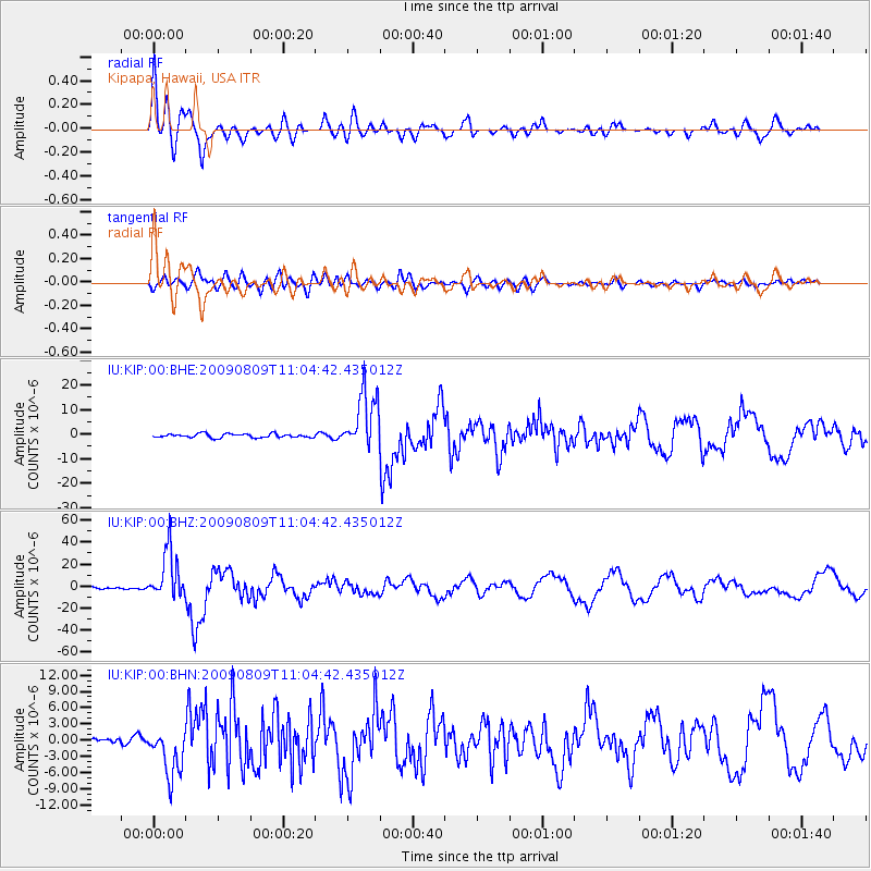
Signal To Noise
| Channel | StoN | STA | LTA |
| IU:KIP:00:BHZ:20090809T11:04:42.435012Z | 21.514849 | 2.2252225E-5 | 1.0342728E-6 |
| IU:KIP:00:BHN:20090809T11:04:42.435012Z | 9.554954 | 4.530451E-6 | 4.7414684E-7 |
| IU:KIP:00:BHE:20090809T11:04:42.435012Z | 15.147164 | 1.1832053E-5 | 7.811398E-7 |
| Arrivals |
| Ps | 5.8 SECOND |
| PpPs | 16 SECOND |
| PsPs/PpSs | 22 SECOND |


