You are here: Home > Network List > IU - Global Seismograph Network (GSN - IRIS/USGS) Stations List
> Station KIP Kipapa, Hawaii, USA > Earthquake Result Viewer
KIP Kipapa, Hawaii, USA - Earthquake Result Viewer
| Earthquake location: |
Banda Sea |
| Earthquake latitude/longitude: |
-7.1/123.4 |
| Earthquake time(UTC): |
2009/08/28 (240) 01:51:20 GMT |
| Earthquake Depth: |
642 km |
| Earthquake Magnitude: |
6.3 MB, 6.9 MW, 6.9 MW |
| Earthquake Catalog/Contributor: |
WHDF/NEIC |
|
| Network: |
IU Global Seismograph Network (GSN - IRIS/USGS) |
| Station: |
KIP Kipapa, Hawaii, USA |
| Lat/Lon: |
21.42 N/158.01 W |
| Elevation: |
110 m |
|
| Distance: |
82.0 deg |
| Az: |
67.241 deg |
| Baz: |
259.14 deg |
| Ray Param: |
0.045181975 |
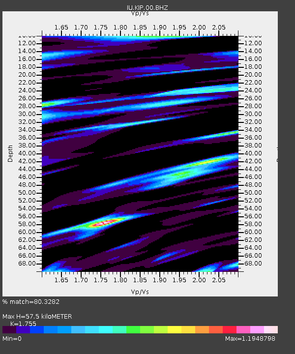
| Estimated Moho Depth: |
57.5 km |
| Estimated Crust Vp/Vs: |
1.75 |
| Assumed Crust Vp: |
4.24 km/s |
| Estimated Crust Vs: |
2.416 km/s |
| Estimated Crust Poisson's Ratio: |
0.26 |
|
| Radial Match: |
80.3282 % |
| Radial Bump: |
400 |
| Transverse Match: |
59.30836 % |
| Transverse Bump: |
400 |
| SOD ConfigId: |
2622 |
| Insert Time: |
2010-03-03 16:37:13.441 +0000 |
| GWidth: |
2.5 |
| Max Bumps: |
400 |
| Tol: |
0.001 |
|

Signal To Noise
| Channel | StoN | STA | LTA |
| IU:KIP:00:BHZ:20090828T02:02:04.186011Z | 2.2824008 | 4.895322E-6 | 2.1448125E-6 |
| IU:KIP:00:BHN:20090828T02:02:04.186011Z | 1.8824816 | 1.587479E-6 | 8.432906E-7 |
| IU:KIP:00:BHE:20090828T02:02:04.186011Z | 2.7994184 | 3.2399423E-6 | 1.1573626E-6 |
| Arrivals |
| Ps | 10 SECOND |
| PpPs | 37 SECOND |
| PsPs/PpSs | 47 SECOND |


