You are here: Home > Network List > IU - Global Seismograph Network (GSN - IRIS/USGS) Stations List
> Station KIP Kipapa, Hawaii, USA > Earthquake Result Viewer
KIP Kipapa, Hawaii, USA - Earthquake Result Viewer
| Earthquake location: |
North Of Honduras |
| Earthquake latitude/longitude: |
16.7/-86.2 |
| Earthquake time(UTC): |
2009/05/28 (148) 08:24:45 GMT |
| Earthquake Depth: |
10 km |
| Earthquake Magnitude: |
6.7 MB, 7.2 MS, 7.3 MW, 7.3 MW |
| Earthquake Catalog/Contributor: |
WHDF/NEIC |
|
| Network: |
IU Global Seismograph Network (GSN - IRIS/USGS) |
| Station: |
KIP Kipapa, Hawaii, USA |
| Lat/Lon: |
21.42 N/158.01 W |
| Elevation: |
70 m |
|
| Distance: |
67.5 deg |
| Az: |
286.65 deg |
| Baz: |
80.176 deg |
| Ray Param: |
0.056927226 |
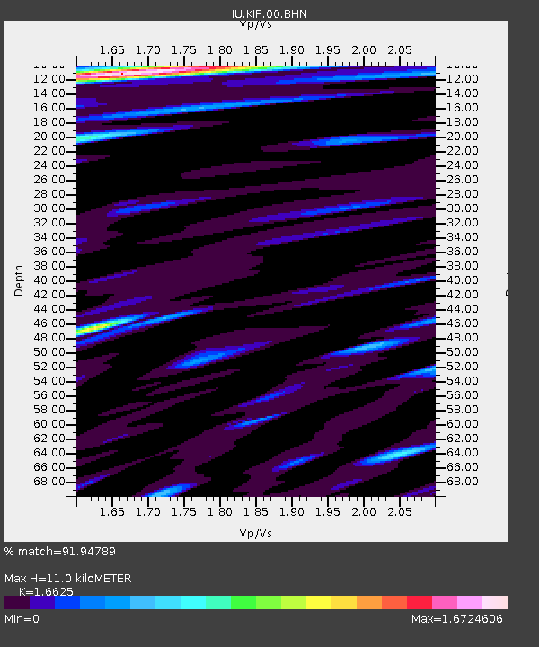
| Estimated Moho Depth: |
11.0 km |
| Estimated Crust Vp/Vs: |
1.66 |
| Assumed Crust Vp: |
4.24 km/s |
| Estimated Crust Vs: |
2.55 km/s |
| Estimated Crust Poisson's Ratio: |
0.22 |
|
| Radial Match: |
91.94789 % |
| Radial Bump: |
400 |
| Transverse Match: |
89.972305 % |
| Transverse Bump: |
400 |
| SOD ConfigId: |
2648 |
| Insert Time: |
2010-03-03 16:37:15.116 +0000 |
| GWidth: |
2.5 |
| Max Bumps: |
400 |
| Tol: |
0.001 |
|
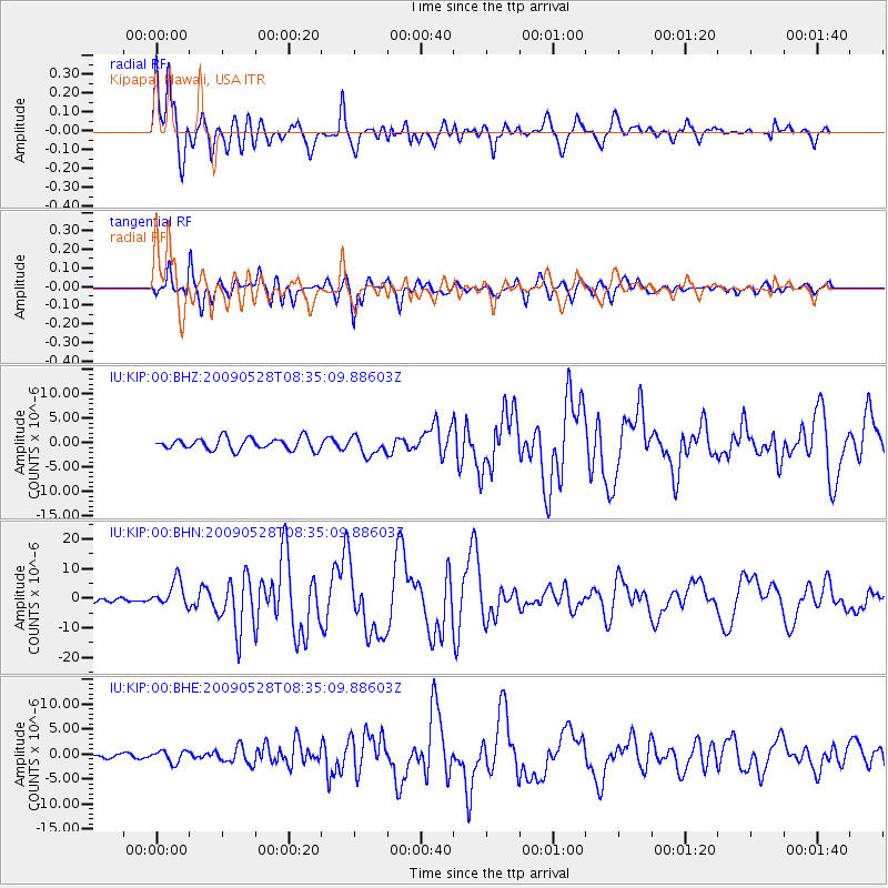
Signal To Noise
| Channel | StoN | STA | LTA |
| IU:KIP:00:BHN:20090528T08:35:09.88603Z | 5.3449535 | 4.3807004E-6 | 8.1959564E-7 |
| IU:KIP:00:BHE:20090528T08:35:09.88603Z | 1.54025 | 1.2058525E-6 | 7.8289406E-7 |
| IU:KIP:00:BHZ:20090528T08:35:09.88603Z | 1.5007885 | 1.8404315E-6 | 1.2263098E-6 |
| Arrivals |
| Ps | 1.7 SECOND |
| PpPs | 6.8 SECOND |
| PsPs/PpSs | 8.5 SECOND |


