You are here: Home > Network List > IU - Global Seismograph Network (GSN - IRIS/USGS) Stations List
> Station KIP Kipapa, Hawaii, USA > Earthquake Result Viewer
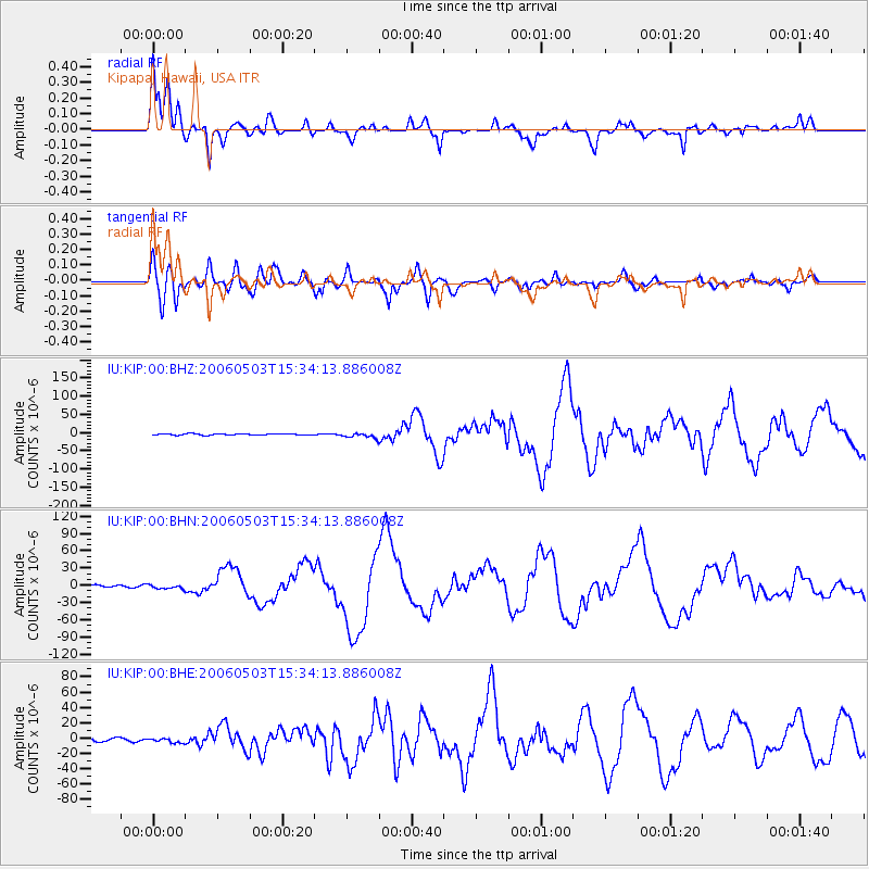
KIP Kipapa, Hawaii, USA - Earthquake Result Viewer
| Earthquake location: |
Tonga Islands |
| Earthquake latitude/longitude: |
-20.2/-174.1 |
| Earthquake time(UTC): |
2006/05/03 (123) 15:26:40 GMT |
| Earthquake Depth: |
55 km |
| Earthquake Magnitude: |
7.2 MB, 7.8 MS, 7.9 MW, 7.9 MW |
| Earthquake Catalog/Contributor: |
WHDF/NEIC |
|
| Network: |
IU Global Seismograph Network (GSN - IRIS/USGS) |
| Station: |
KIP Kipapa, Hawaii, USA |
| Lat/Lon: |
21.42 N/158.01 W |
| Elevation: |
70 m |
|
| Distance: |
44.3 deg |
| Az: |
21.743 deg |
| Baz: |
201.929 deg |
| Ray Param: |
0.07188076 |
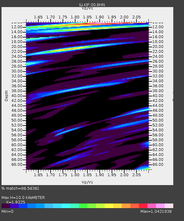
| Estimated Moho Depth: |
10.0 km |
| Estimated Crust Vp/Vs: |
1.92 |
| Assumed Crust Vp: |
4.24 km/s |
| Estimated Crust Vs: |
2.205 km/s |
| Estimated Crust Poisson's Ratio: |
0.31 |
|
| Radial Match: |
86.56361 % |
| Radial Bump: |
353 |
| Transverse Match: |
84.066956 % |
| Transverse Bump: |
400 |
| SOD ConfigId: |
2669 |
| Insert Time: |
2010-03-03 16:37:19.220 +0000 |
| GWidth: |
2.5 |
| Max Bumps: |
400 |
| Tol: |
0.001 |
|
Signal To Noise
| Channel | StoN | STA | LTA |
| IU:KIP:00:BHN:20060503T15:34:13.886008Z | 1.833901 | 3.660307E-6 | 1.995913E-6 |
| IU:KIP:00:BHE:20060503T15:34:13.886008Z | 1.0929835 | 2.9481953E-6 | 2.697383E-6 |
| IU:KIP:00:BHZ:20060503T15:34:13.886008Z | 3.7300258 | 6.6679563E-6 | 1.7876434E-6 |
| Arrivals |
| Ps | 2.2 SECOND |
| PpPs | 6.7 SECOND |
| PsPs/PpSs | 9.0 SECOND |


