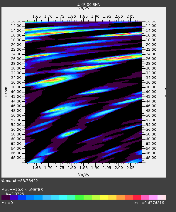
KIP Kipapa, Hawaii, USA - Earthquake Result Viewer
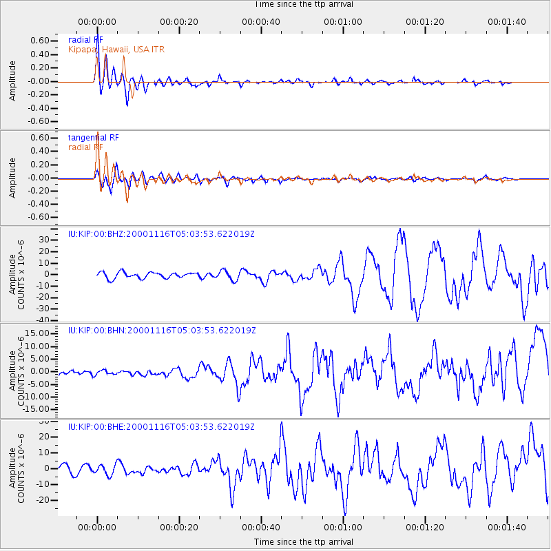
Earthquake location: New Ireland Region, P.N.G.
Earthquake latitude/longitude: -4.0/152.2
Earthquake time(UTC): 2000/11/16 (321) 04:54:56 GMT
Earthquake Depth: 33 km
Earthquake Magnitude: 6.0 MB, 8.2 MS, 8.0 MW, 8.0 ME
Earthquake Catalog/Contributor: WHDF/NEIC
Network: IU Global Seismograph Network (GSN - IRIS/USGS)
Station: KIP Kipapa, Hawaii, USA
Lat/Lon: 21.42 N/158.01 W
Elevation: 70 m
Distance: 54.9 deg
Az: 60.44 deg
Baz: 248.645 deg
Ray Param: 0.06507662
Estimated Moho Depth: 15.0 km
Estimated Crust Vp/Vs: 2.07
Assumed Crust Vp: 4.24 km/s
Estimated Crust Vs: 2.046 km/s
Estimated Crust Poisson's Ratio: 0.35
Radial Match: 88.78422 %
Radial Bump: 400
Transverse Match: 85.019844 %
Transverse Bump: 400
SOD ConfigId: 3744
Insert Time: 2010-03-03 16:37:24.158 +0000
GWidth: 2.5
Max Bumps: 400
Tol: 0.001

Signal To Noise

ChannelStoNSTALTA
IU:KIP:00:BHN:20001116T05:03:53.622019Z0.78125498.821065E-71.1290894E-6
IU:KIP:00:BHE:20001116T05:03:53.622019Z1.36058333.2897462E-62.417894E-6
IU:KIP:00:BHZ:20001116T05:03:53.622019Z1.6232574.187328E-62.5795841E-6
Arrivals
Ps3.9 SECOND
PpPs11 SECOND
PsPs/PpSs15 SECOND