You are here: Home > Network List > IU - Global Seismograph Network (GSN - IRIS/USGS) Stations List
> Station KIP Kipapa, Hawaii, USA > Earthquake Result Viewer
KIP Kipapa, Hawaii, USA - Earthquake Result Viewer
| Earthquake location: |
Sulawesi, Indonesia |
| Earthquake latitude/longitude: |
-1.1/123.6 |
| Earthquake time(UTC): |
2000/05/04 (125) 04:21:16 GMT |
| Earthquake Depth: |
26 km |
| Earthquake Magnitude: |
6.7 MB, 7.5 MS, 7.6 MW, 7.5 ME |
| Earthquake Catalog/Contributor: |
WHDF/NEIC |
|
| Network: |
IU Global Seismograph Network (GSN - IRIS/USGS) |
| Station: |
KIP Kipapa, Hawaii, USA |
| Lat/Lon: |
21.42 N/158.01 W |
| Elevation: |
70 m |
|
| Distance: |
79.6 deg |
| Az: |
68.115 deg |
| Baz: |
264.705 deg |
| Ray Param: |
0.048805084 |
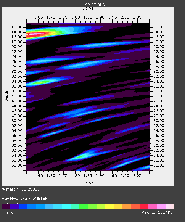
| Estimated Moho Depth: |
14.75 km |
| Estimated Crust Vp/Vs: |
1.61 |
| Assumed Crust Vp: |
4.24 km/s |
| Estimated Crust Vs: |
2.638 km/s |
| Estimated Crust Poisson's Ratio: |
0.18 |
|
| Radial Match: |
88.25865 % |
| Radial Bump: |
400 |
| Transverse Match: |
86.980835 % |
| Transverse Bump: |
400 |
| SOD ConfigId: |
3744 |
| Insert Time: |
2010-03-03 16:37:26.414 +0000 |
| GWidth: |
2.5 |
| Max Bumps: |
400 |
| Tol: |
0.001 |
|

Signal To Noise
| Channel | StoN | STA | LTA |
| IU:KIP:00:BHN:20000504T04:32:49.897012Z | 1.188442 | 1.5590025E-6 | 1.3118035E-6 |
| IU:KIP:00:BHE:20000504T04:32:49.897012Z | 0.8119536 | 1.2409338E-6 | 1.5283309E-6 |
| IU:KIP:00:BHZ:20000504T04:32:49.897012Z | 0.573855 | 1.3653977E-6 | 2.3793427E-6 |
| Arrivals |
| Ps | 2.1 SECOND |
| PpPs | 8.9 SECOND |
| PsPs/PpSs | 11 SECOND |


