You are here: Home > Network List > IU - Global Seismograph Network (GSN - IRIS/USGS) Stations List
> Station KIP Kipapa, Hawaii, USA > Earthquake Result Viewer
KIP Kipapa, Hawaii, USA - Earthquake Result Viewer
| Earthquake location: |
Kermadec Islands, New Zealand |
| Earthquake latitude/longitude: |
-29.7/-178.6 |
| Earthquake time(UTC): |
2001/06/03 (154) 02:41:57 GMT |
| Earthquake Depth: |
178 km |
| Earthquake Magnitude: |
6.8 MB, 7.2 MW, 7.1 MW |
| Earthquake Catalog/Contributor: |
WHDF/NEIC |
|
| Network: |
IU Global Seismograph Network (GSN - IRIS/USGS) |
| Station: |
KIP Kipapa, Hawaii, USA |
| Lat/Lon: |
21.42 N/158.01 W |
| Elevation: |
70 m |
|
| Distance: |
54.5 deg |
| Az: |
23.755 deg |
| Baz: |
202.104 deg |
| Ray Param: |
0.064778686 |
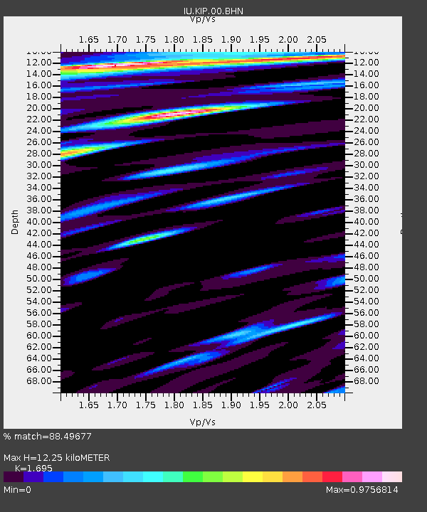
| Estimated Moho Depth: |
12.25 km |
| Estimated Crust Vp/Vs: |
1.70 |
| Assumed Crust Vp: |
4.24 km/s |
| Estimated Crust Vs: |
2.501 km/s |
| Estimated Crust Poisson's Ratio: |
0.23 |
|
| Radial Match: |
88.49677 % |
| Radial Bump: |
400 |
| Transverse Match: |
78.4199 % |
| Transverse Bump: |
400 |
| SOD ConfigId: |
4714 |
| Insert Time: |
2010-03-03 16:37:38.694 +0000 |
| GWidth: |
2.5 |
| Max Bumps: |
400 |
| Tol: |
0.001 |
|

Signal To Noise
| Channel | StoN | STA | LTA |
| IU:KIP:00:BHN:20010603T02:50:36.022Z | 1.6489128 | 1.3299887E-6 | 8.065852E-7 |
| IU:KIP:00:BHE:20010603T02:50:36.022Z | 1.3551966 | 1.632596E-6 | 1.204693E-6 |
| IU:KIP:00:BHZ:20010603T02:50:36.022Z | 3.51339 | 2.5134398E-6 | 7.153888E-7 |
| Arrivals |
| Ps | 2.1 SECOND |
| PpPs | 7.6 SECOND |
| PsPs/PpSs | 9.7 SECOND |


