KIP Kipapa, Hawaii, USA - Earthquake Result Viewer
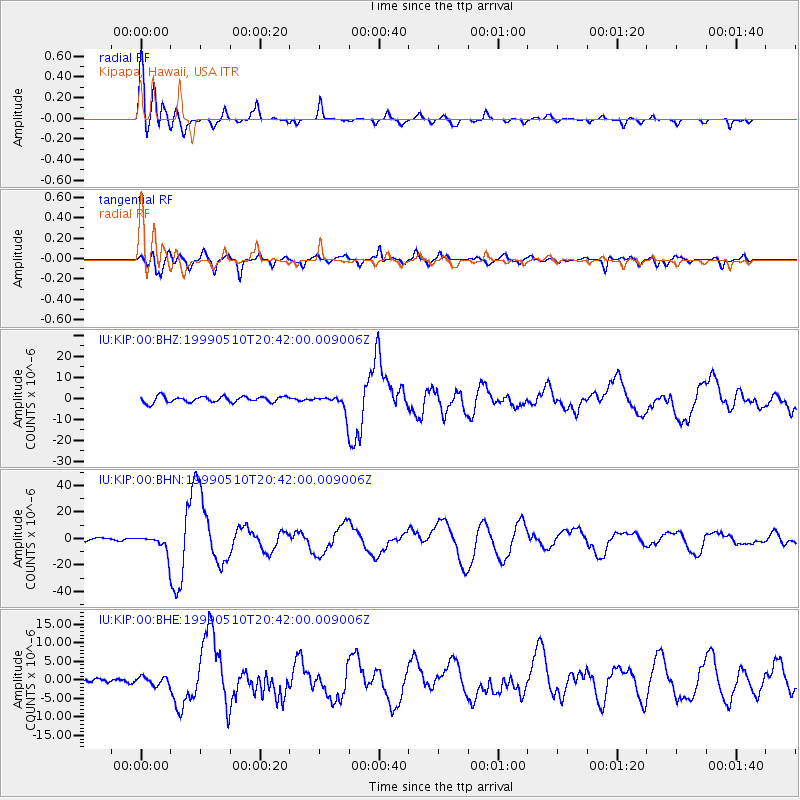
Earthquake location: New Britain Region, P.N.G.
Earthquake latitude/longitude: -5.2/150.9
Earthquake time(UTC): 1999/05/10 (130) 20:33:02 GMT
Earthquake Depth: 138 km
Earthquake Magnitude: 6.5 MB, 6.8 MS, 7.1 MW, 6.5 MB
Earthquake Catalog/Contributor: WHDF/NEIC
Network: IU Global Seismograph Network (GSN - IRIS/USGS)
Station: KIP Kipapa, Hawaii, USA
Lat/Lon: 21.42 N/158.01 W
Elevation: 70 m
Distance: 56.6 deg
Az: 60.282 deg
Baz: 248.183 deg
Ray Param: 0.06358937
Estimated Moho Depth: 30.0 km
Estimated Crust Vp/Vs: 1.81
Assumed Crust Vp: 4.24 km/s
Estimated Crust Vs: 2.343 km/s
Estimated Crust Poisson's Ratio: 0.28
Radial Match: 90.230125 %
Radial Bump: 400
Transverse Match: 78.11041 %
Transverse Bump: 400
SOD ConfigId: 4480
Insert Time: 2010-03-03 16:37:41.416 +0000
GWidth: 2.5
Max Bumps: 400
Tol: 0.001

Signal To Noise

ChannelStoNSTALTA
IU:KIP:00:BHN:19990510T20:42:00.009006Z2.92256287.09889E-62.4289948E-6
IU:KIP:00:BHE:19990510T20:42:00.009006Z1.56436611.143997E-67.312847E-7
IU:KIP:00:BHZ:19990510T20:42:00.009006Z2.8823734.061757E-61.409171E-6
Arrivals
Ps5.9 SECOND
PpPs19 SECOND
PsPs/PpSs25 SECOND