You are here: Home > Network List > IU - Global Seismograph Network (GSN - IRIS/USGS) Stations List
> Station KIP Kipapa, Hawaii, USA > Earthquake Result Viewer
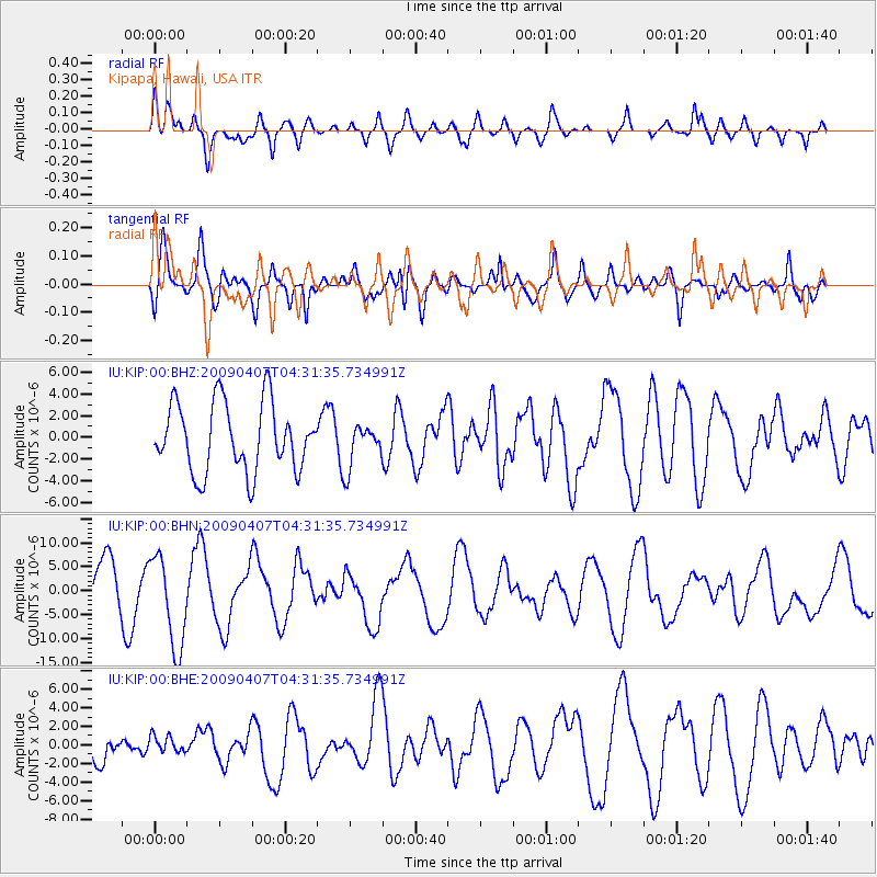
KIP Kipapa, Hawaii, USA - Earthquake Result Viewer
*The percent match for this event was below the threshold and hence no stack was calculated.
| Earthquake location: |
Kuril Islands |
| Earthquake latitude/longitude: |
46.0/151.5 |
| Earthquake time(UTC): |
2009/04/07 (097) 04:23:33 GMT |
| Earthquake Depth: |
31 km |
| Earthquake Magnitude: |
6.5 MB, 6.8 MS, 6.9 MW, 6.9 MW |
| Earthquake Catalog/Contributor: |
WHDF/NEIC |
|
| Network: |
IU Global Seismograph Network (GSN - IRIS/USGS) |
| Station: |
KIP Kipapa, Hawaii, USA |
| Lat/Lon: |
21.42 N/158.01 W |
| Elevation: |
70 m |
|
| Distance: |
47.6 deg |
| Az: |
103.538 deg |
| Baz: |
313.389 deg |
| Ray Param: |
$rayparam |
*The percent match for this event was below the threshold and hence was not used in the summary stack. |
|
| Radial Match: |
49.51288 % |
| Radial Bump: |
400 |
| Transverse Match: |
60.433926 % |
| Transverse Bump: |
400 |
| SOD ConfigId: |
2658 |
| Insert Time: |
2010-03-03 16:37:47.255 +0000 |
| GWidth: |
2.5 |
| Max Bumps: |
400 |
| Tol: |
0.001 |
|
Signal To Noise
| Channel | StoN | STA | LTA |
| IU:KIP:00:BHN:20090407T04:31:35.734991Z | 2.4484074 | 9.52982E-6 | 3.8922526E-6 |
| IU:KIP:00:BHE:20090407T04:31:35.734991Z | 0.48241833 | 9.194774E-7 | 1.9059752E-6 |
| IU:KIP:00:BHZ:20090407T04:31:35.734991Z | 0.62306166 | 1.976702E-6 | 3.1725624E-6 |
| Arrivals |
| Ps | |
| PpPs | |
| PsPs/PpSs | |


