You are here: Home > Network List > IU - Global Seismograph Network (GSN - IRIS/USGS) Stations List
> Station KIP Kipapa, Hawaii, USA > Earthquake Result Viewer
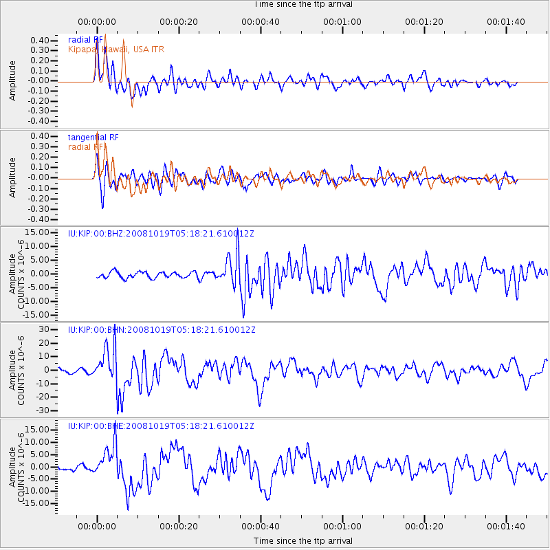
KIP Kipapa, Hawaii, USA - Earthquake Result Viewer
*The percent match for this event was below the threshold and hence no stack was calculated.
| Earthquake location: |
Tonga Islands |
| Earthquake latitude/longitude: |
-21.9/-173.8 |
| Earthquake time(UTC): |
2008/10/19 (293) 05:10:33 GMT |
| Earthquake Depth: |
29 km |
| Earthquake Magnitude: |
6.8 MB, 7.0 MS, 6.9 MW, 6.9 MW |
| Earthquake Catalog/Contributor: |
WHDF/NEIC |
|
| Network: |
IU Global Seismograph Network (GSN - IRIS/USGS) |
| Station: |
KIP Kipapa, Hawaii, USA |
| Lat/Lon: |
21.42 N/158.01 W |
| Elevation: |
70 m |
|
| Distance: |
45.7 deg |
| Az: |
20.765 deg |
| Baz: |
200.7 deg |
| Ray Param: |
$rayparam |
*The percent match for this event was below the threshold and hence was not used in the summary stack. |
|
| Radial Match: |
82.815674 % |
| Radial Bump: |
400 |
| Transverse Match: |
79.89531 % |
| Transverse Bump: |
400 |
| SOD ConfigId: |
2556 |
| Insert Time: |
2010-03-03 16:37:56.216 +0000 |
| GWidth: |
2.5 |
| Max Bumps: |
400 |
| Tol: |
0.001 |
|
Signal To Noise
| Channel | StoN | STA | LTA |
| IU:KIP:00:BHN:20081019T05:18:21.610012Z | 8.945163 | 1.3449667E-5 | 1.5035688E-6 |
| IU:KIP:00:BHE:20081019T05:18:21.610012Z | 10.221266 | 7.0820447E-6 | 6.928735E-7 |
| IU:KIP:00:BHZ:20081019T05:18:21.610012Z | 5.3665485 | 5.840279E-6 | 1.0882746E-6 |
| Arrivals |
| Ps | |
| PpPs | |
| PsPs/PpSs | |


