You are here: Home > Network List > IU - Global Seismograph Network (GSN - IRIS/USGS) Stations List
> Station KIP Kipapa, Hawaii, USA > Earthquake Result Viewer
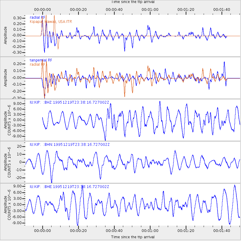
KIP Kipapa, Hawaii, USA - Earthquake Result Viewer
*The percent match for this event was below the threshold and hence no stack was calculated.
| Earthquake location: |
Irian Jaya, Indonesia |
| Earthquake latitude/longitude: |
-3.7/140.3 |
| Earthquake time(UTC): |
1995/12/19 (353) 23:28:12 GMT |
| Earthquake Depth: |
71 km |
| Earthquake Magnitude: |
6.2 MB, 6.5 UNKNOWN |
| Earthquake Catalog/Contributor: |
WHDF/NEIC |
|
| Network: |
IU Global Seismograph Network (GSN - IRIS/USGS) |
| Station: |
KIP Kipapa, Hawaii, USA |
| Lat/Lon: |
21.42 N/158.01 W |
| Elevation: |
70 m |
|
| Distance: |
65.3 deg |
| Az: |
64.541 deg |
| Baz: |
255.252 deg |
| Ray Param: |
$rayparam |
*The percent match for this event was below the threshold and hence was not used in the summary stack. |
|
| Radial Match: |
64.32748 % |
| Radial Bump: |
400 |
| Transverse Match: |
51.4548 % |
| Transverse Bump: |
400 |
| SOD ConfigId: |
4480 |
| Insert Time: |
2010-03-03 16:38:13.557 +0000 |
| GWidth: |
2.5 |
| Max Bumps: |
400 |
| Tol: |
0.001 |
|
Signal To Noise
| Channel | StoN | STA | LTA |
| IU:KIP: :BHN:19951219T23:38:16.727002Z | 2.803684 | 1.1135707E-5 | 3.9718125E-6 |
| IU:KIP: :BHE:19951219T23:38:16.727002Z | 0.51614326 | 2.311144E-6 | 4.477718E-6 |
| IU:KIP: :BHZ:19951219T23:38:16.727002Z | 1.2262301 | 3.4382729E-6 | 2.8039378E-6 |
| Arrivals |
| Ps | |
| PpPs | |
| PsPs/PpSs | |


