You are here: Home > Network List > IU - Global Seismograph Network (GSN - IRIS/USGS) Stations List
> Station KIP Kipapa, Hawaii, USA > Earthquake Result Viewer
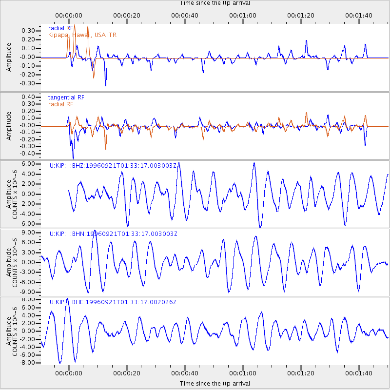
KIP Kipapa, Hawaii, USA - Earthquake Result Viewer
*The percent match for this event was below the threshold and hence no stack was calculated.
| Earthquake location: |
Eastern New Guinea Reg., P.N.G. |
| Earthquake latitude/longitude: |
-6.2/146.2 |
| Earthquake time(UTC): |
1996/09/21 (265) 01:23:33 GMT |
| Earthquake Depth: |
10 km |
| Earthquake Magnitude: |
5.7 MB, 5.8 MS, 5.9 UNKNOWN |
| Earthquake Catalog/Contributor: |
WHDF/NEIC |
|
| Network: |
IU Global Seismograph Network (GSN - IRIS/USGS) |
| Station: |
KIP Kipapa, Hawaii, USA |
| Lat/Lon: |
21.42 N/158.01 W |
| Elevation: |
70 m |
|
| Distance: |
61.2 deg |
| Az: |
61.594 deg |
| Baz: |
249.83 deg |
| Ray Param: |
$rayparam |
*The percent match for this event was below the threshold and hence was not used in the summary stack. |
|
| Radial Match: |
49.902054 % |
| Radial Bump: |
267 |
| Transverse Match: |
55.60289 % |
| Transverse Bump: |
400 |
| SOD ConfigId: |
4480 |
| Insert Time: |
2010-03-03 16:38:19.758 +0000 |
| GWidth: |
2.5 |
| Max Bumps: |
400 |
| Tol: |
0.001 |
|
Signal To Noise
| Channel | StoN | STA | LTA |
| IU:KIP: :BHN:19960921T01:33:17.003003Z | 1.1808279 | 2.6306693E-6 | 2.227818E-6 |
| IU:KIP: :BHE:19960921T01:33:17.002026Z | 2.6717412 | 5.0968806E-6 | 1.9077E-6 |
| IU:KIP: :BHZ:19960921T01:33:17.003003Z | 0.6391152 | 1.35233E-6 | 2.1159408E-6 |
| Arrivals |
| Ps | |
| PpPs | |
| PsPs/PpSs | |


