You are here: Home > Network List > IU - Global Seismograph Network (GSN - IRIS/USGS) Stations List
> Station KIP Kipapa, Hawaii, USA > Earthquake Result Viewer
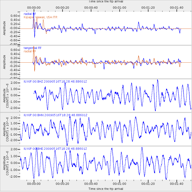
KIP Kipapa, Hawaii, USA - Earthquake Result Viewer
*The percent match for this event was below the threshold and hence no stack was calculated.
| Earthquake location: |
Kodiak Island Region, Alaska |
| Earthquake latitude/longitude: |
56.4/-152.4 |
| Earthquake time(UTC): |
2009/05/16 (136) 18:22:25 GMT |
| Earthquake Depth: |
9.7 km |
| Earthquake Magnitude: |
5.9 MS, 5.4 MB, 5.9 MW, 5.8 MW |
| Earthquake Catalog/Contributor: |
WHDF/NEIC |
|
| Network: |
IU Global Seismograph Network (GSN - IRIS/USGS) |
| Station: |
KIP Kipapa, Hawaii, USA |
| Lat/Lon: |
21.42 N/158.01 W |
| Elevation: |
70 m |
|
| Distance: |
35.2 deg |
| Az: |
189.053 deg |
| Baz: |
5.383 deg |
| Ray Param: |
$rayparam |
*The percent match for this event was below the threshold and hence was not used in the summary stack. |
|
| Radial Match: |
59.635925 % |
| Radial Bump: |
400 |
| Transverse Match: |
61.537766 % |
| Transverse Bump: |
265 |
| SOD ConfigId: |
2760 |
| Insert Time: |
2010-03-03 16:38:22.978 +0000 |
| GWidth: |
2.5 |
| Max Bumps: |
400 |
| Tol: |
0.001 |
|
Signal To Noise
| Channel | StoN | STA | LTA |
| IU:KIP:00:BHN:20090516T18:28:48.88601Z | 0.5391188 | 4.8834846E-7 | 9.058271E-7 |
| IU:KIP:00:BHE:20090516T18:28:48.88601Z | 2.0014253 | 1.4522928E-6 | 7.256293E-7 |
| IU:KIP:00:BHZ:20090516T18:28:48.88601Z | 0.993802 | 8.784574E-7 | 8.83936E-7 |
| Arrivals |
| Ps | |
| PpPs | |
| PsPs/PpSs | |


