You are here: Home > Network List > NM - Cooperative New Madrid Seismic Network Stations List
> Station PENM Penman,Portageville,MO > Earthquake Result Viewer
PENM Penman,Portageville,MO - Earthquake Result Viewer
| Earthquake location: |
Northern Colombia |
| Earthquake latitude/longitude: |
6.8/-73.0 |
| Earthquake time(UTC): |
2015/03/10 (069) 20:55:43 GMT |
| Earthquake Depth: |
147 km |
| Earthquake Magnitude: |
6.2 MWB |
| Earthquake Catalog/Contributor: |
NEIC PDE/NEIC COMCAT |
|
| Network: |
NM Cooperative New Madrid Seismic Network |
| Station: |
PENM Penman,Portageville,MO |
| Lat/Lon: |
36.45 N/89.63 W |
| Elevation: |
85 m |
|
| Distance: |
33.2 deg |
| Az: |
335.076 deg |
| Baz: |
148.734 deg |
| Ray Param: |
0.07788394 |
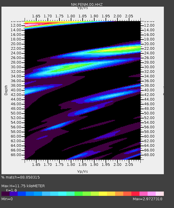
| Estimated Moho Depth: |
11.75 km |
| Estimated Crust Vp/Vs: |
1.60 |
| Assumed Crust Vp: |
6.444 km/s |
| Estimated Crust Vs: |
4.027 km/s |
| Estimated Crust Poisson's Ratio: |
0.18 |
|
| Radial Match: |
88.858315 % |
| Radial Bump: |
375 |
| Transverse Match: |
82.59184 % |
| Transverse Bump: |
360 |
| SOD ConfigId: |
872571 |
| Insert Time: |
2015-03-24 21:17:01.973 +0000 |
| GWidth: |
2.5 |
| Max Bumps: |
400 |
| Tol: |
0.001 |
|

Signal To Noise
| Channel | StoN | STA | LTA |
| NM:PENM:00:HHZ:20150310T21:01:35.494996Z | 24.520899 | 1.0531479E-5 | 4.2948992E-7 |
| NM:PENM:00:HHN:20150310T21:01:35.494996Z | 10.034198 | 5.484228E-6 | 5.465537E-7 |
| NM:PENM:00:HHE:20150310T21:01:35.494996Z | 5.6316733 | 3.0657495E-6 | 5.443763E-7 |
| Arrivals |
| Ps | 1.2 SECOND |
| PpPs | 4.3 SECOND |
| PsPs/PpSs | 5.5 SECOND |


