You are here: Home > Network List > IU - Global Seismograph Network (GSN - IRIS/USGS) Stations List
> Station KIP Kipapa, Hawaii, USA > Earthquake Result Viewer
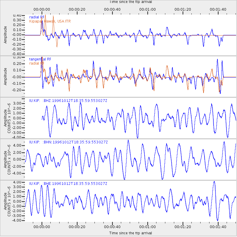
KIP Kipapa, Hawaii, USA - Earthquake Result Viewer
*The percent match for this event was below the threshold and hence no stack was calculated.
| Earthquake location: |
Solomon Islands |
| Earthquake latitude/longitude: |
-7.3/155.4 |
| Earthquake time(UTC): |
1996/10/12 (286) 18:27:10 GMT |
| Earthquake Depth: |
33 km |
| Earthquake Magnitude: |
5.6 MS, 5.3 MB, 5.9 UNKNOWN, 5.8 MW |
| Earthquake Catalog/Contributor: |
WHDF/NEIC |
|
| Network: |
IU Global Seismograph Network (GSN - IRIS/USGS) |
| Station: |
KIP Kipapa, Hawaii, USA |
| Lat/Lon: |
21.42 N/158.01 W |
| Elevation: |
70 m |
|
| Distance: |
53.9 deg |
| Az: |
56.924 deg |
| Baz: |
243.149 deg |
| Ray Param: |
$rayparam |
*The percent match for this event was below the threshold and hence was not used in the summary stack. |
|
| Radial Match: |
56.81529 % |
| Radial Bump: |
388 |
| Transverse Match: |
60.894943 % |
| Transverse Bump: |
400 |
| SOD ConfigId: |
4480 |
| Insert Time: |
2010-03-03 16:38:45.869 +0000 |
| GWidth: |
2.5 |
| Max Bumps: |
400 |
| Tol: |
0.001 |
|
Signal To Noise
| Channel | StoN | STA | LTA |
| IU:KIP: :BHN:19961012T18:35:59.553027Z | 0.60859907 | 1.182081E-6 | 1.9422982E-6 |
| IU:KIP: :BHE:19961012T18:35:59.553027Z | 2.1272063 | 2.3266662E-6 | 1.0937662E-6 |
| IU:KIP: :BHZ:19961012T18:35:59.553027Z | 0.56387407 | 9.2548953E-7 | 1.6413054E-6 |
| Arrivals |
| Ps | |
| PpPs | |
| PsPs/PpSs | |


