You are here: Home > Network List > CI - Caltech Regional Seismic Network Stations List
> Station GLA Glamis, California, USA > Earthquake Result Viewer
GLA Glamis, California, USA - Earthquake Result Viewer
| Earthquake location: |
New Ireland Region, P.N.G. |
| Earthquake latitude/longitude: |
-4.0/152.2 |
| Earthquake time(UTC): |
2000/11/16 (321) 04:54:56 GMT |
| Earthquake Depth: |
33 km |
| Earthquake Magnitude: |
6.0 MB, 8.2 MS, 8.0 MW, 8.0 ME |
| Earthquake Catalog/Contributor: |
WHDF/NEIC |
|
| Network: |
CI Caltech Regional Seismic Network |
| Station: |
GLA Glamis, California, USA |
| Lat/Lon: |
33.05 N/114.83 W |
| Elevation: |
627 m |
|
| Distance: |
94.7 deg |
| Az: |
57.297 deg |
| Baz: |
268.303 deg |
| Ray Param: |
0.04097304 |
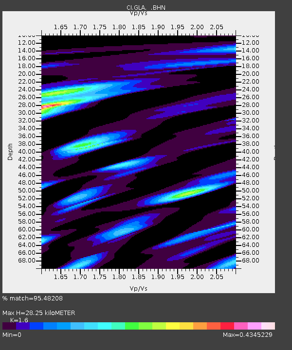
| Estimated Moho Depth: |
28.25 km |
| Estimated Crust Vp/Vs: |
1.60 |
| Assumed Crust Vp: |
6.155 km/s |
| Estimated Crust Vs: |
3.847 km/s |
| Estimated Crust Poisson's Ratio: |
0.18 |
|
| Radial Match: |
95.48208 % |
| Radial Bump: |
332 |
| Transverse Match: |
78.41384 % |
| Transverse Bump: |
400 |
| SOD ConfigId: |
3744 |
| Insert Time: |
2010-02-25 21:41:31.225 +0000 |
| GWidth: |
2.5 |
| Max Bumps: |
400 |
| Tol: |
0.001 |
|

Signal To Noise
| Channel | StoN | STA | LTA |
| CI:GLA: :BHN:20001116T05:07:43.086008Z | 0.40807593 | 8.836764E-8 | 2.1654706E-7 |
| CI:GLA: :BHE:20001116T05:07:43.086008Z | 1.3392855 | 2.7944182E-7 | 2.0864992E-7 |
| CI:GLA: :BHZ:20001116T05:07:43.086008Z | 0.536917 | 1.6697648E-7 | 3.1099125E-7 |
| Arrivals |
| Ps | 2.8 SECOND |
| PpPs | 12 SECOND |
| PsPs/PpSs | 15 SECOND |


