You are here: Home > Network List > US - United States National Seismic Network Stations List
> Station AMTX Amarillo, Texas, USA > Earthquake Result Viewer
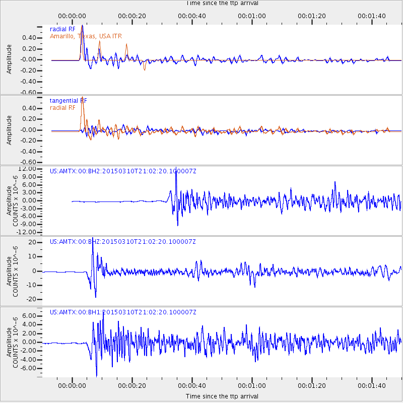
AMTX Amarillo, Texas, USA - Earthquake Result Viewer
*The percent match for this event was below the threshold and hence no stack was calculated.
| Earthquake location: |
Northern Colombia |
| Earthquake latitude/longitude: |
6.8/-73.0 |
| Earthquake time(UTC): |
2015/03/10 (069) 20:55:43 GMT |
| Earthquake Depth: |
147 km |
| Earthquake Magnitude: |
6.2 MWB |
| Earthquake Catalog/Contributor: |
NEIC PDE/NEIC COMCAT |
|
| Network: |
US United States National Seismic Network |
| Station: |
AMTX Amarillo, Texas, USA |
| Lat/Lon: |
34.53 N/101.41 W |
| Elevation: |
1010 m |
|
| Distance: |
38.0 deg |
| Az: |
320.396 deg |
| Baz: |
129.938 deg |
| Ray Param: |
$rayparam |
*The percent match for this event was below the threshold and hence was not used in the summary stack. |
|
| Radial Match: |
90.271126 % |
| Radial Bump: |
400 |
| Transverse Match: |
79.076164 % |
| Transverse Bump: |
400 |
| SOD ConfigId: |
872571 |
| Insert Time: |
2015-03-24 21:18:04.489 +0000 |
| GWidth: |
2.5 |
| Max Bumps: |
400 |
| Tol: |
0.001 |
|
Signal To Noise
| Channel | StoN | STA | LTA |
| US:AMTX:00:BHZ:20150310T21:02:20.100007Z | 1.3997747 | 2.2939243E-7 | 1.6387811E-7 |
| US:AMTX:00:BH1:20150310T21:02:20.100007Z | 1.0980351 | 1.258747E-7 | 1.1463633E-7 |
| US:AMTX:00:BH2:20150310T21:02:20.100007Z | 2.0794501 | 2.1158789E-7 | 1.01751844E-7 |
| Arrivals |
| Ps | |
| PpPs | |
| PsPs/PpSs | |


