You are here: Home > Network List > IU - Global Seismograph Network (GSN - IRIS/USGS) Stations List
> Station KIP Kipapa, Hawaii, USA > Earthquake Result Viewer
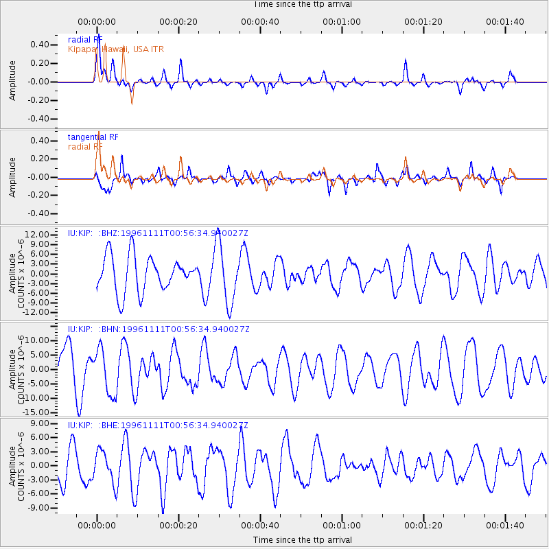
KIP Kipapa, Hawaii, USA - Earthquake Result Viewer
*The percent match for this event was below the threshold and hence no stack was calculated.
| Earthquake location: |
South Of Kermadec Islands |
| Earthquake latitude/longitude: |
-32.5/-179.0 |
| Earthquake time(UTC): |
1996/11/11 (316) 00:47:21 GMT |
| Earthquake Depth: |
33 km |
| Earthquake Magnitude: |
5.9 MB, 5.9 MS, 6.1 UNKNOWN, 6.0 MW |
| Earthquake Catalog/Contributor: |
WHDF/NEIC |
|
| Network: |
IU Global Seismograph Network (GSN - IRIS/USGS) |
| Station: |
KIP Kipapa, Hawaii, USA |
| Lat/Lon: |
21.42 N/158.01 W |
| Elevation: |
70 m |
|
| Distance: |
57.3 deg |
| Az: |
23.415 deg |
| Baz: |
201.116 deg |
| Ray Param: |
$rayparam |
*The percent match for this event was below the threshold and hence was not used in the summary stack. |
|
| Radial Match: |
58.45238 % |
| Radial Bump: |
358 |
| Transverse Match: |
62.72155 % |
| Transverse Bump: |
400 |
| SOD ConfigId: |
4480 |
| Insert Time: |
2010-03-03 16:39:10.967 +0000 |
| GWidth: |
2.5 |
| Max Bumps: |
400 |
| Tol: |
0.001 |
|
Signal To Noise
| Channel | StoN | STA | LTA |
| IU:KIP: :BHN:19961111T00:56:34.940027Z | 1.1558931 | 8.019918E-6 | 6.9382872E-6 |
| IU:KIP: :BHE:19961111T00:56:34.940027Z | 0.7895887 | 3.4038587E-6 | 4.3109267E-6 |
| IU:KIP: :BHZ:19961111T00:56:34.940027Z | 1.7012675 | 9.300674E-6 | 5.4669085E-6 |
| Arrivals |
| Ps | |
| PpPs | |
| PsPs/PpSs | |


